DGS Expands Opportunities with New Geospatial Lab
September 6, 2022
Room 2.103—with its rows of computer terminals lit by a western window in the EP Schoch Building—may not be glamorous, but there is a steady buzz of excitement emanating from it. This room will be home to the new Texas Digital Remote Observation and Education Laboratory (Tx DRONE), a recently created lab devoted to geospatial computing and remote sensing.
“I’m incredibly excited about the new Tx DRONE lab,” says Timothy Goudge, an assistant professor in the Department of Geological Sciences (DGS) in the Jackson School of Geosciences. “This combined teaching and research lab will provide Jackson School students and scientists access to, and training in, state of the art geospatial computing and remote sensing software and hardware.”
The new departmental education lab—generously funded by the DGS’s Student Equipment Fund— includes a large fleet of drones, or Uncrewed Aerial Vehicles (UAVs), with traditional imaging cameras attached. These drones are capable of surveying and imaging large areas in the field, such as an exposed outcrop or active geological systems like rivers or a dune field. The data associated with these images can also be further processed with equipment in the lab, combining images with geospatial software to produce highly detailed maps of surface elevation using a technique called Structure from Motion (SfM).
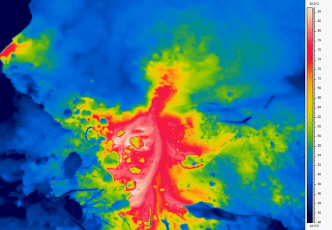
The lab also includes cutting edge UAV technology, such as a thermal infrared camera, which will allow users to map out temperature variations to study everything from hydrothermal systems to urban temperature environments.
But the key part of this lab is that it will integrate new research methods with teaching in the Jackson School.
“Geospatial learning, and in particular use of UAVs, is a fast-evolving part of the geoscience profession, and having our students graduate with this skill set will be a huge benefit for employers and set our students up for success,” says Goudge. “It is innovative ideas and labs like these that keep UT at the forefront of geoscience education, and I am keen to see where this new endeavor goes!”
“The creation of this educational facility has been a top priority of mine as DGS Chair,” adds Daniel Stockli, a professor in the department. “In today’s geosciences, remote sensing skills, together with foundational quantitative and computational skills, are critical and desired by employers. I am truly delighted that we were able to make this strategic investment in DGS this summer and hope that it will help transform field and experiential courses for JSG students and expose them new cutting-edge methods of field data collection in the 21st century.”