Geoscience Walking Tour
Explore Today’s Earth and Planetary Sciences
Spend an hour discovering the ground beneath Texas, distinguishing rock types, and immersing in today’s diverse geoscienes.
Directions: From the Martin Luther King Jr. statue on the East Mall, walk east & slightly north to the Munib and Angela Masri Family Courtyard of the Jackson School of Geosciences. Please print map for easy with audio version of tour.
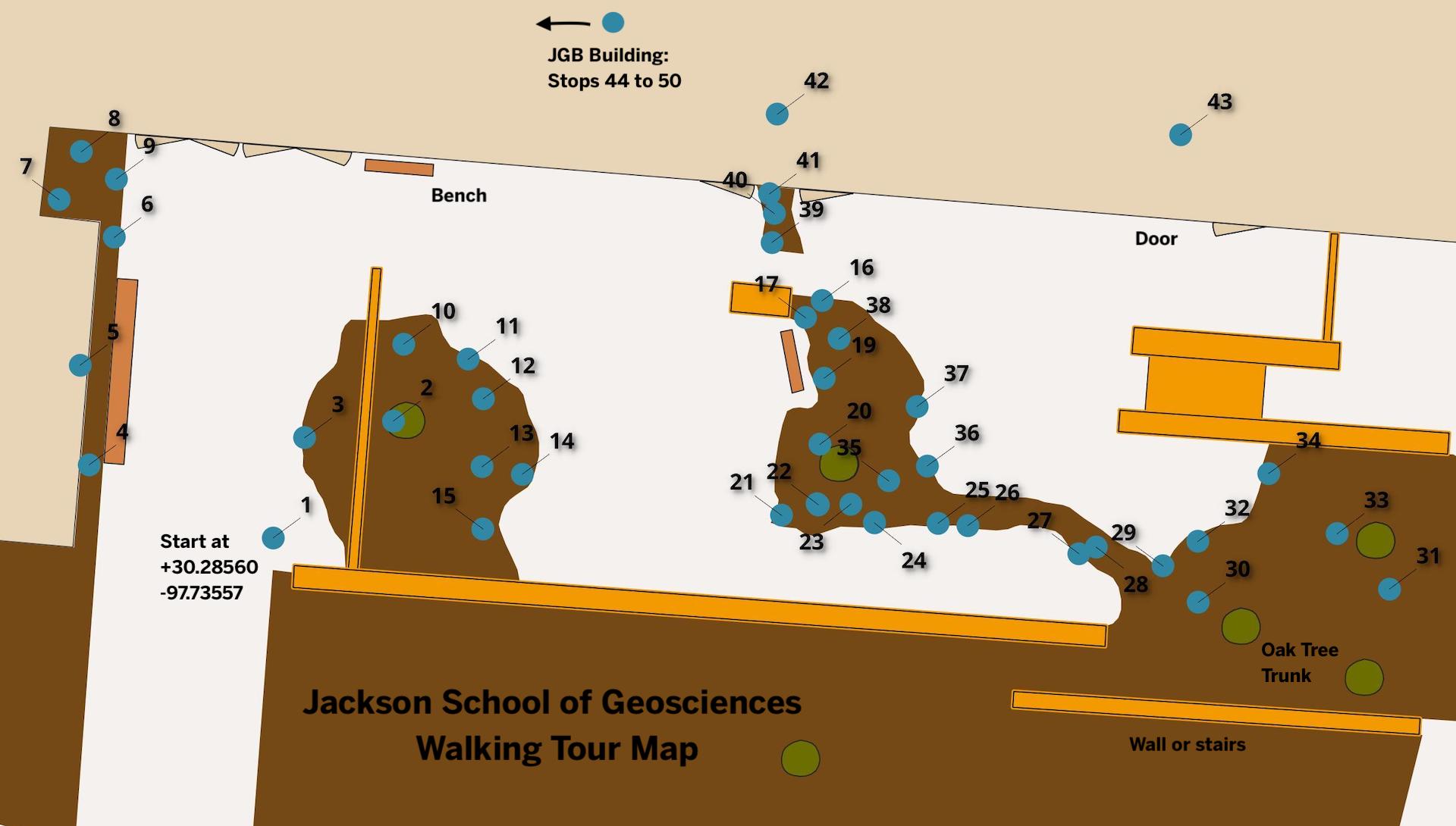
The first stop, on your right, is the sculpture at the courtyard entrance at GPS point +30.28560, -97.73557

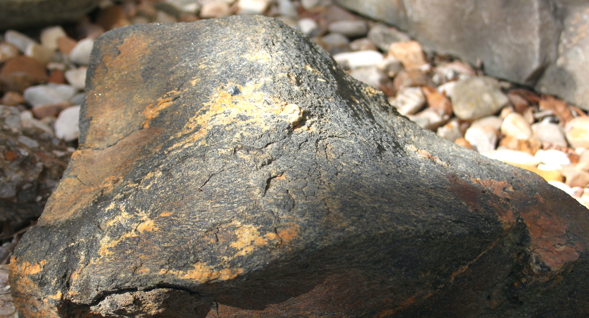
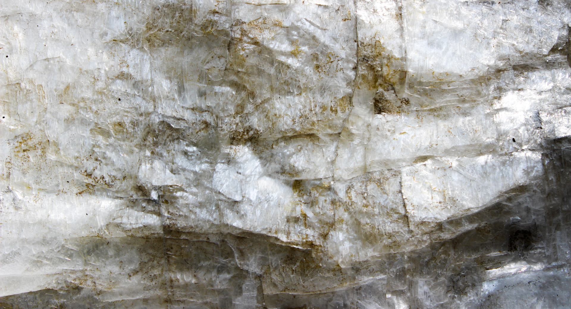
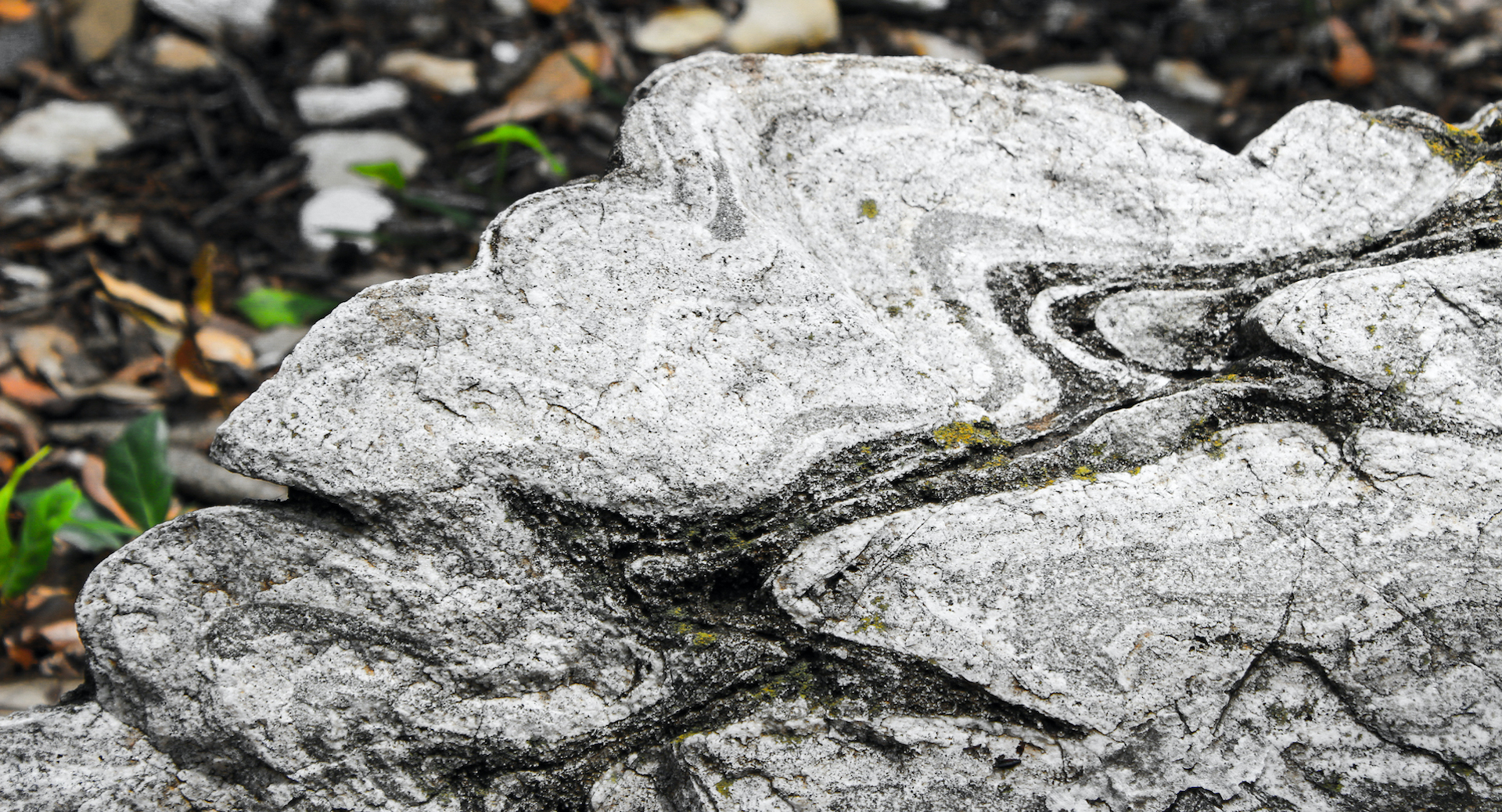
1: Granite that Talks
There are a few who have heard it: a hum emanating from this column of Texas pink granite when a thunderstorm sweeps through Austin or the wind blows a certain way. Created by Jesús Bautista Moroles (1950-2015), the Spirit Inner Column by was completed in 1994 in a studio in Rockport, Texas and is on loan from the Blanton Museum of Art. Moroles—awarded the National Medal of Arts in 2008—created this piece with as an interplay of polished and raw edges.
“My work is a discussion of how man exists in nature and touches nature and uses nature,” Moroles once said. “Each of my pieces has about 50 percent of its surfaces untouched and raw — those are parts of the stone that were torn. The rest of the work is smoothed and polished. The effect, which I want people to not only look at but touch, is a harmonious coexistence of the two.”
Looking closely at the statue, note the large crystals that developed as magma slowly cooled and solidified beneath the Earth’s surface to form granite. Crystals have internal structure that is reflected in their appearance, and some crystals–like those observed here– show zoning, or bands of different colors that represent the changing chemistry of the tiny magma pool within a forming rock as different compounds solidify first.
UT Geo: Within the Jackson School’s walls are state-of-the-art laboratories like the High Resolution X-ray Computed Tomography Facility. Medically, CT scans offer a noninvasive peek inside patients without cutting them open. Here we optimize the technology to image rocks and fossils, which don’t move and don’t get cancer from too many X-rays. Research-wise, this facility imaged the fossil hominin, Lucy, and found evidence that a fall may have caused her death 3.2 million years ago. Recently, faculty member Dr. Richard Ketcham and his team detailed the minute porous structure of a rare carbonaceous chondrite meteorite, a meteorite that contains some of the oldest minerals in the Solar System and possible ingredients for life on Earth.
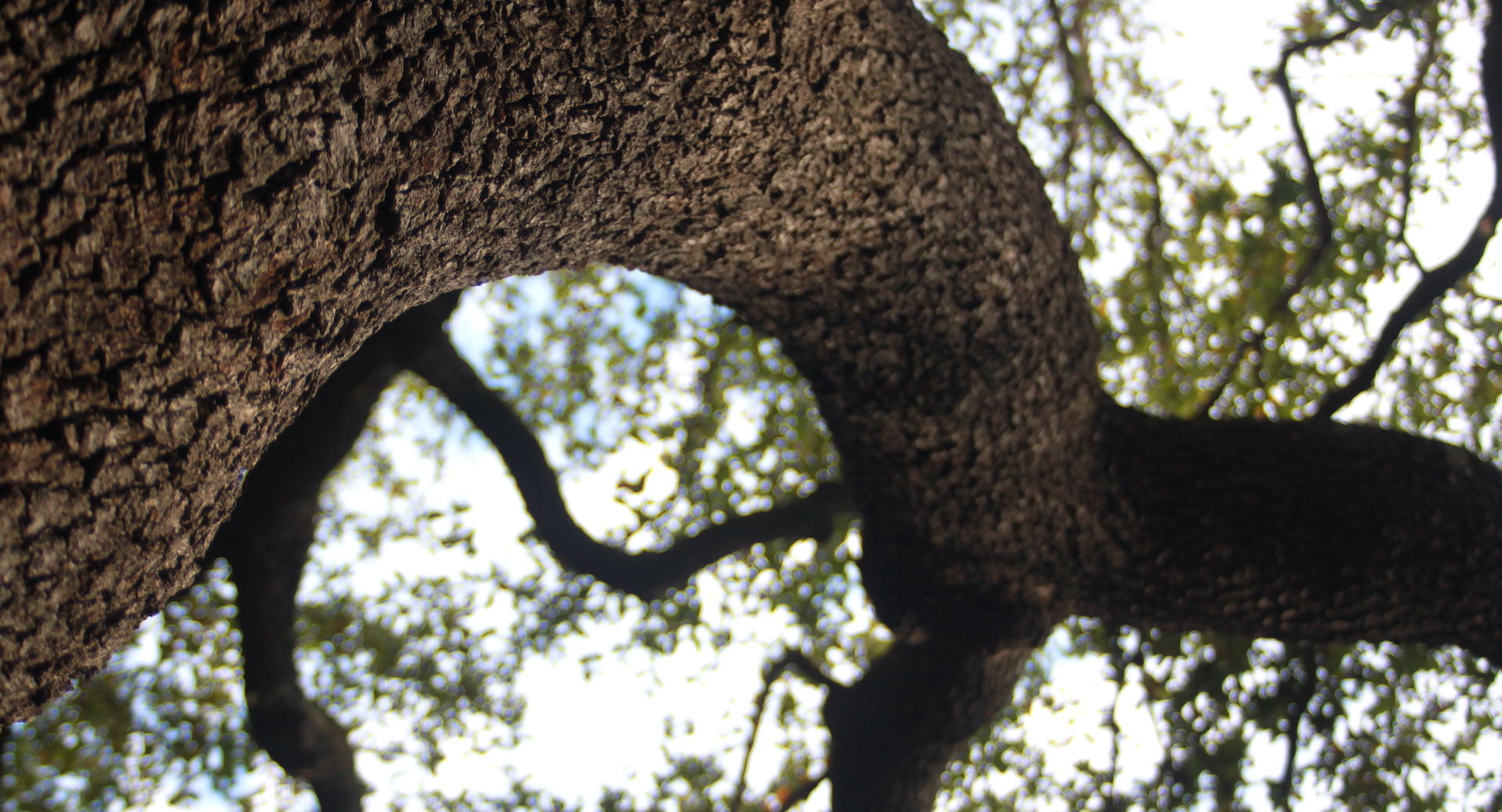
Walk a few steps north & look up: live oak canopy
2: Speaking for the Trees
Of the nearly 5,000 trees on campus, 41% are Southern live oaks (Quercus virginiana) like those that shade the courtyard. A database of all campus trees—maintained by UT Landscape Services—provides information about campus trees through the tag on their trunks. The closest live oak (#2207) towers 45 feet above the ground, providing very real ecological benefits to The University of Texas like improved air quality, water storage, and sequestration of over 600 pounds of CO2 (a greenhouse gas) each year. When all of the campus trees are combined, the yearly eco-benefits are valued to be over half a million dollars.
UT Geo: At a field station near Austin, ecohydrologist Dr. Ashley Matheny uses new technology to measure how much water live oaks and other trees store. When this data is combined with remote-sensing data from NASA satellites, the result—a detailed picture of available water—will better predict drought, tree death, and the likelihood of forest fire.
Look down, under the tree, at the rock garden shaped like a dry-bed arroyo. This is not a random collection of landscaping rocks; instead, it is a teaching collection studied by undergraduates for decades.
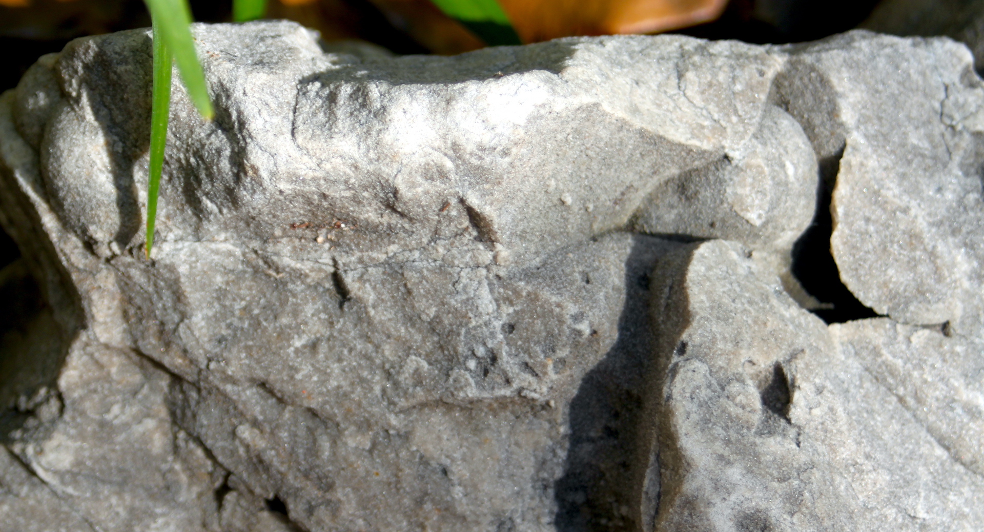
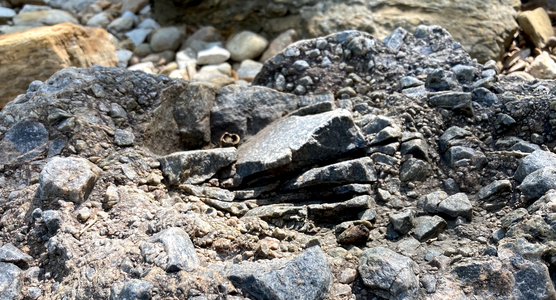
3: Geology 101: Sedimentary Rocks
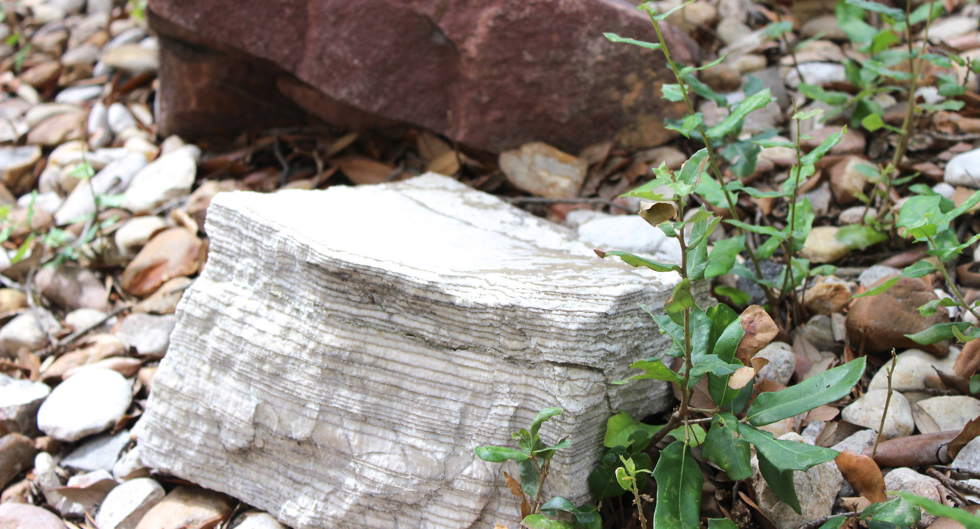
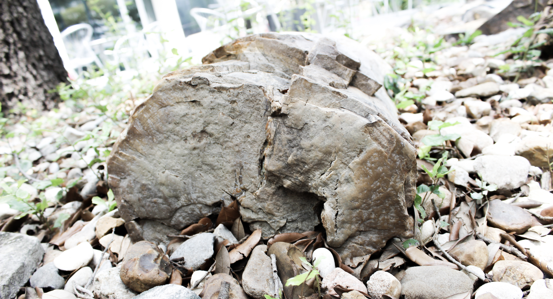
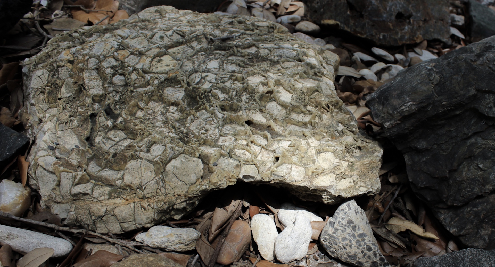
80% of the Earth’s crust is sedimentary rock, or the sandstones, mudstones, and concretions that form from the eroded bits of older rocks. Once loose material, sediment, is transported by rain, wind, and ice and deposited, time can transform it into new rock. Some sediments are created from precipitation of minerals dissolved in solution or from the evaporation of water (chemical sedimentary rock), or the remains of once-living organisms can develop into fossils or even petroleum.
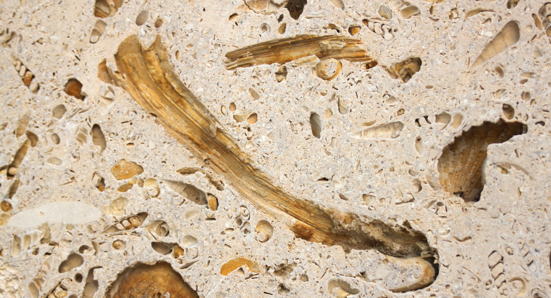
The pale gray rock close to the pathway hails from the East Texas Basin near Gulf Coast. It is fine-grained Carrizo Sandstone that formed after the extinction of the dinosaurs when shallow marine sands were cemented by mineral fluids. These mineral fluids were rich in calcite, the main component of shells, hard parts of red algae and sponges, and plankton from marine environments.
More: From the Carrizo Sandstone, look clockwise to see other sedimentary rocks including (1) a conglomerate, or a rock made of larger pre-existing material, or clasts, (2) a pale brown mudstone or paleosoil, (3) a highly-altered white stone from a hot springs.
UT Geo: The critical zone – the crust of the Earth’s crust, or the outermost layer that combines life, soils, water and air – is the subject of Dr. Daniel Breecker’s research. Recent work used ancient soils to determine the concentration of CO2 in Earth’s atmosphere during the past.
Cross the pathway to the left side of the long bench.
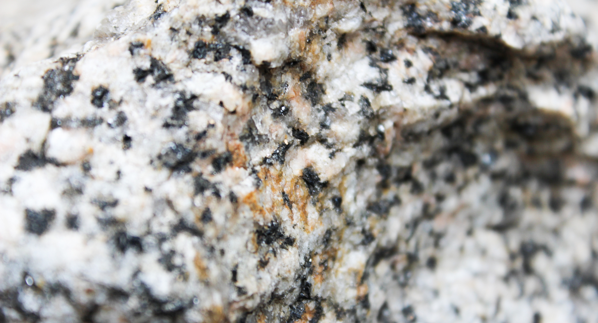
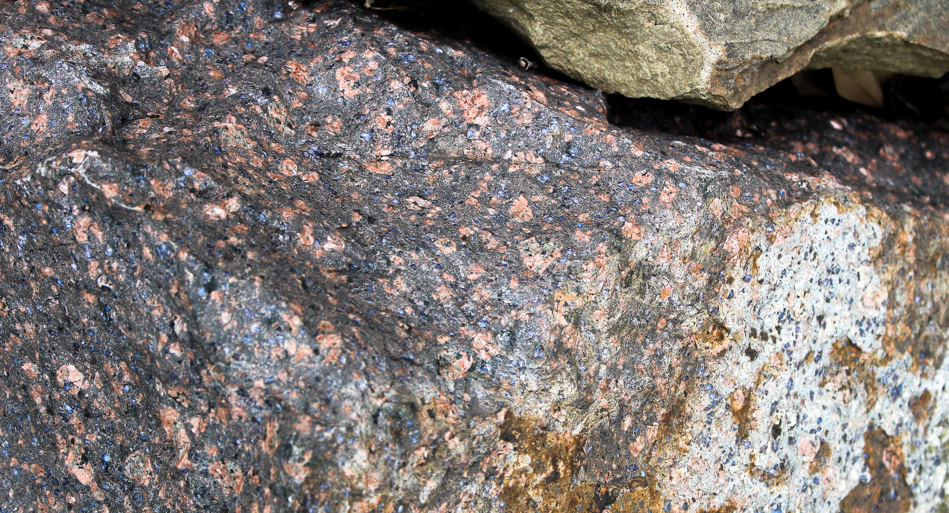
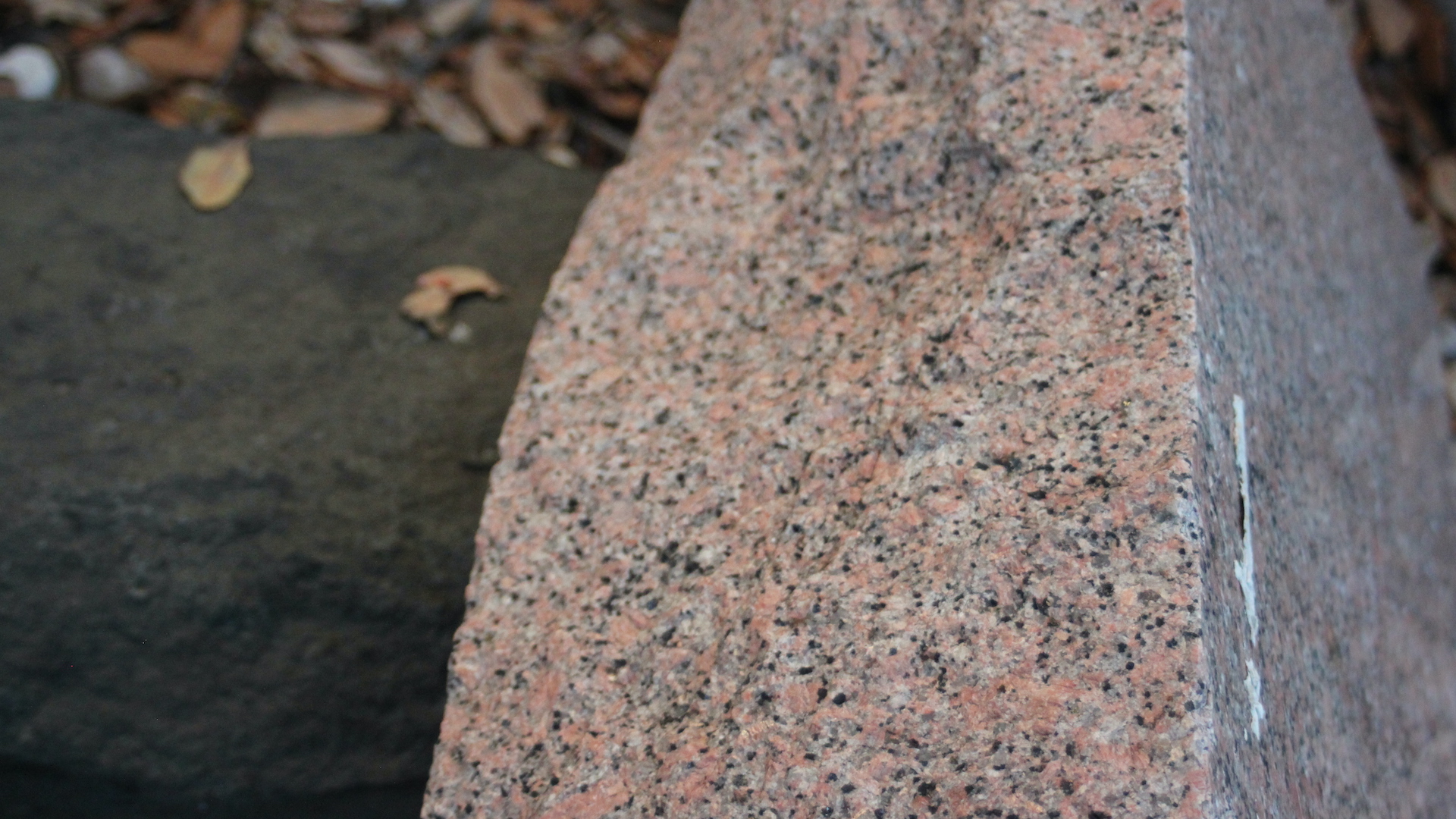
4: Geology 101: Igneous Rocks
When magma—molten material below the Earth’s surface—crystalizes and solidifies, the result is an igneous rock. These rocks are either intrusive, remaining below to slowly cool and form large crystals, or extrusive and formed in the wake of a volcanic eruption. Very close to the bench is a white and black intrusive igneous rock composed of several basic components known as minerals: potassium-rich feldspar (white), calcium-rich feldspar (also white), biotite (black) and quartz (gray). The proportion of the feldspar, biotite and quartz define this rock as a granite.
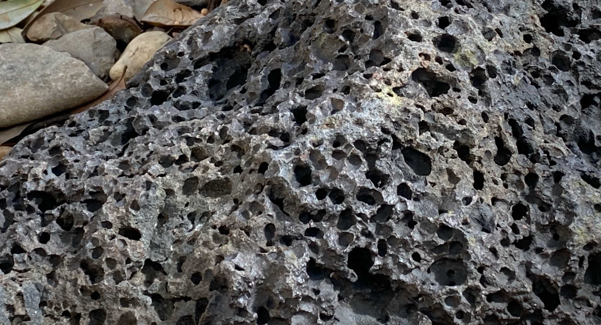
More violent eruptions occur when magma is silica-rich and viscous because the gas within the magma cannot expand and pressure builds. Look right toward a large light gray rock. This ignimbrite (derived from Latin terms meaning fire shower) formed during a more violent volcanic event as indicated by the cavities or vesicles left after gas dissipated. The rock also contains inclusions, or material picked up and altered by the lava flow.
Magmas that are not rich in silica—like some of the basaltic magmas of Hawaii—appear less “pitted” because the eruption is less violent and gasses escape slowly into the atmosphere.
UT Geo: Dr. Jim Gardner studies, among many topics, the formation of calderas, or the depressions that form after a volcano’s eruption. Examples of calderas in the U.S. include Oregon’s Crater Lake and the 13.7-mile-wide Valles supervolcano in northern New Mexico. Recent research on the latter caldera is finding clues to how the magma shifts before and during a supervolcano eruption.
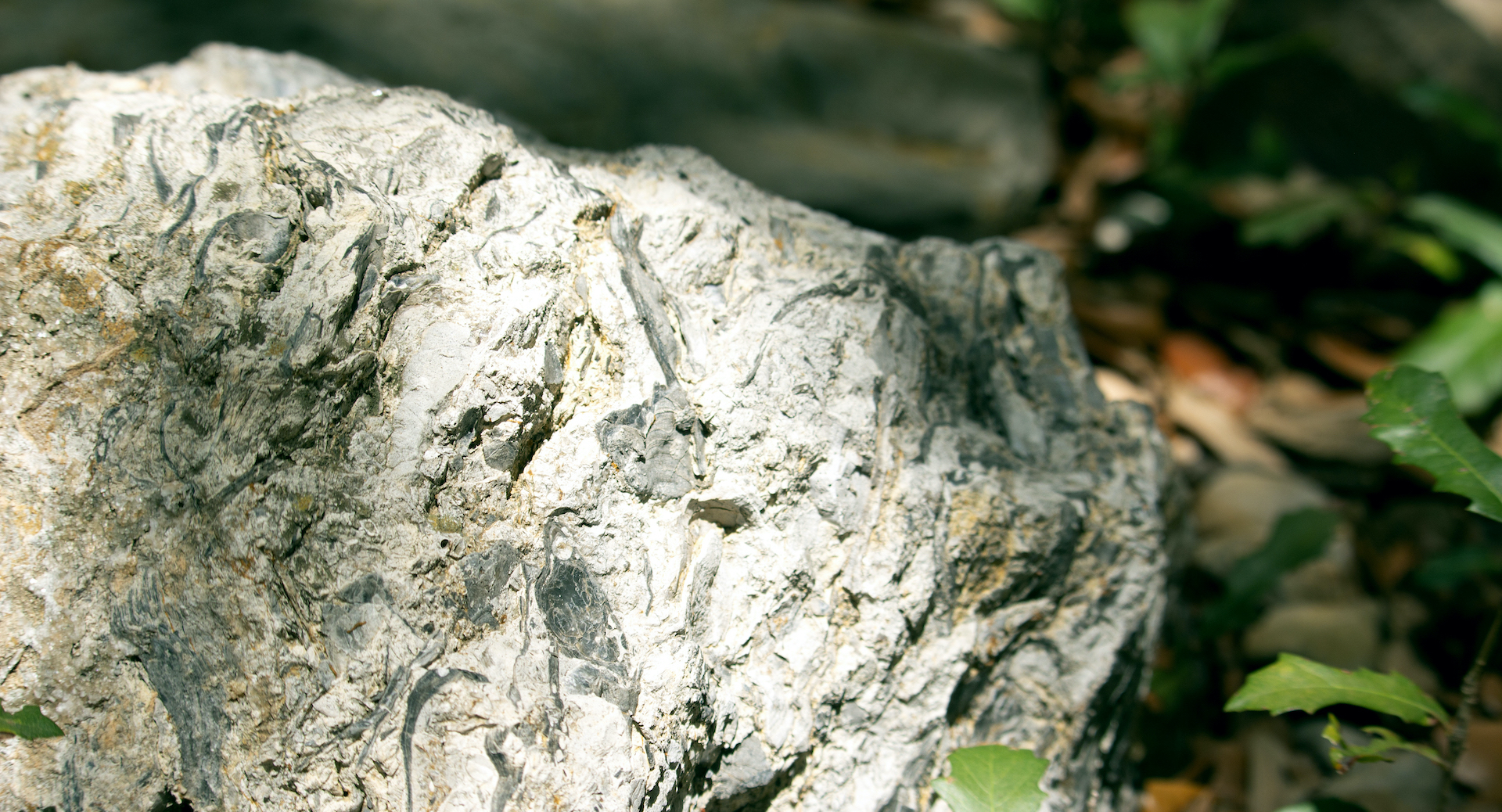
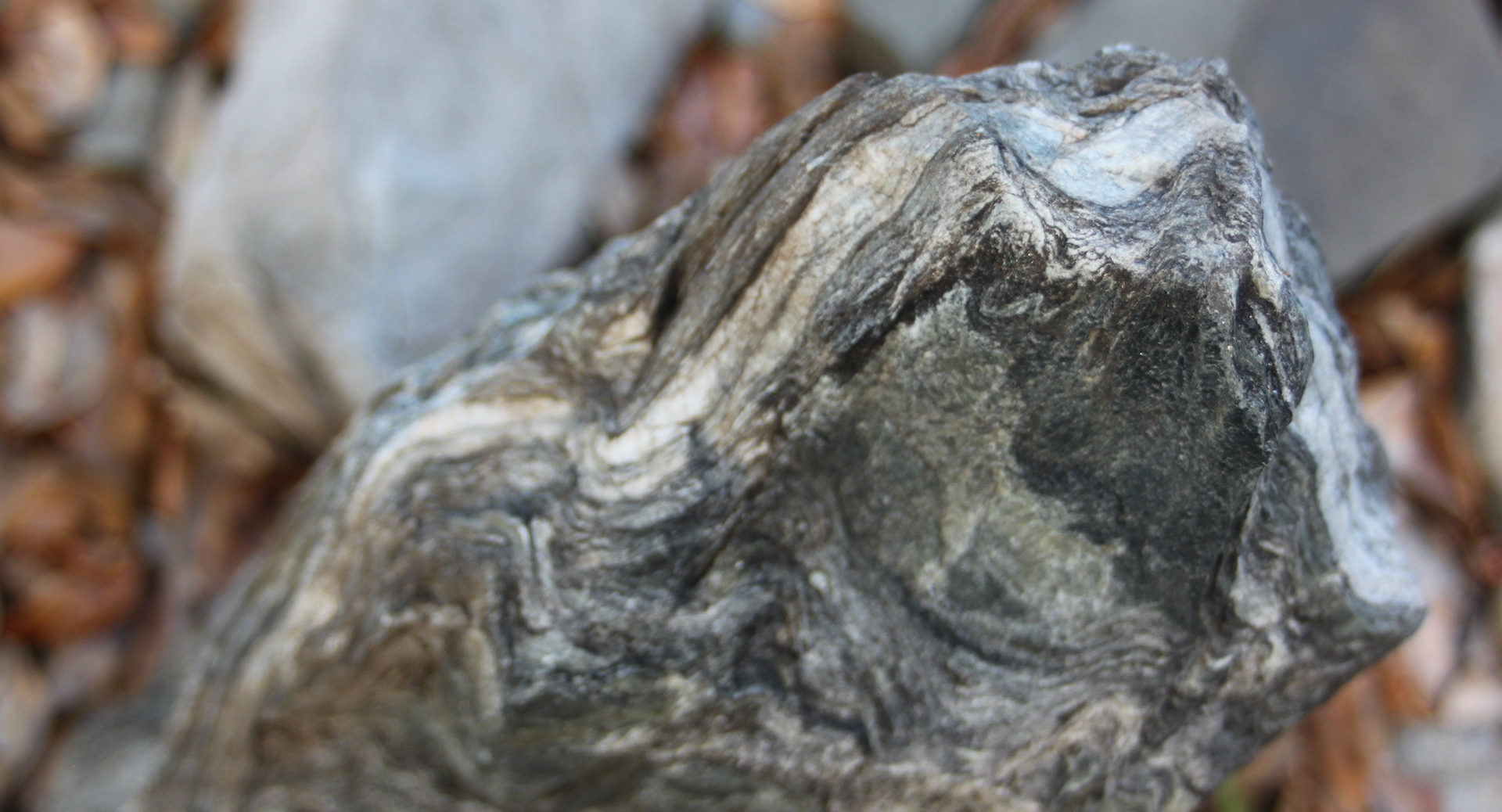
Look closely at the wall behind the bench. What do you see?
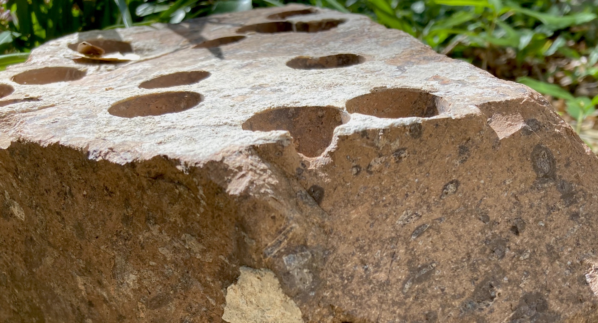
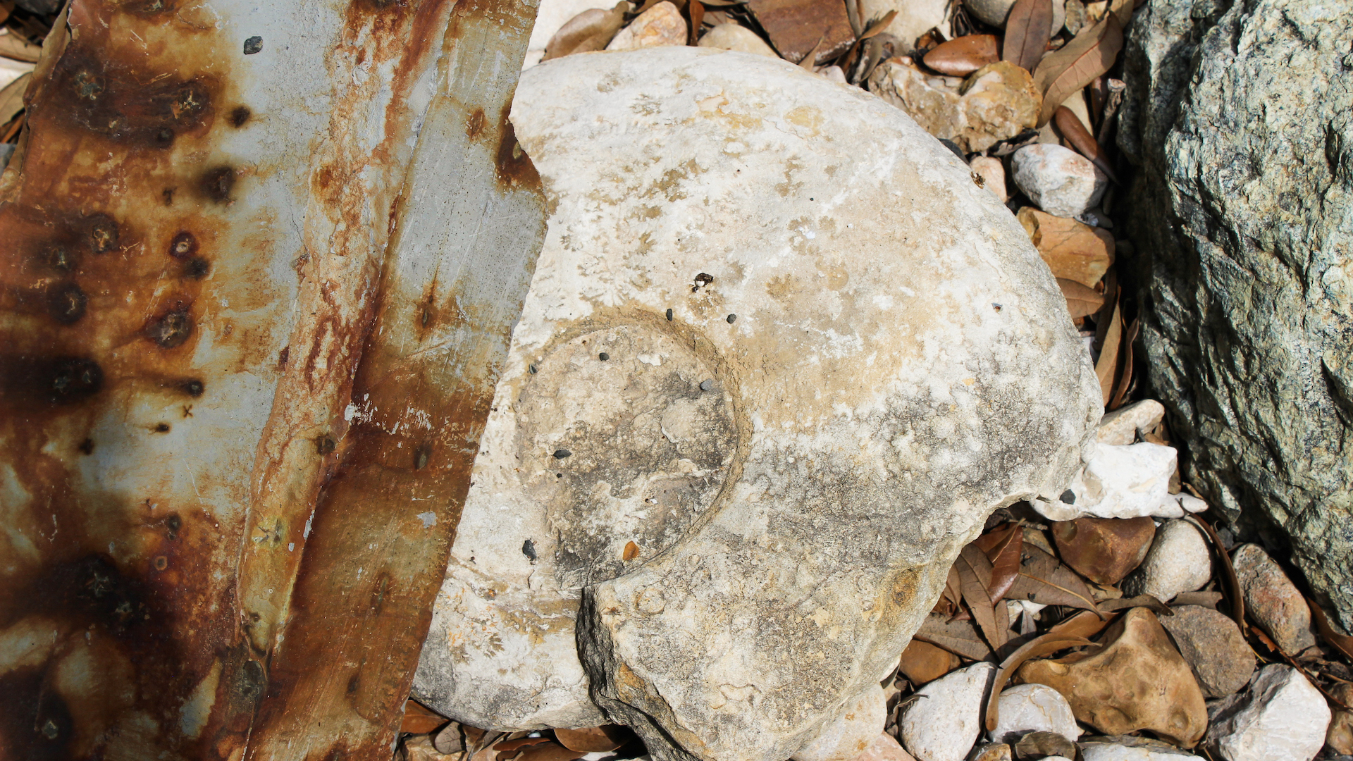
5: Facade of Fossils
For over 40 million years—and ending about 66 mya—Texas teamed with sharks, mosasaurs, ammonites, and bivalves. Texas was under water, covered by the shallow sea named the Western Interior Seaway that split western North America from Appalachia. Over time, the remnants of lifeforms that filtered to the sea’s bottom became limestone, a marine sedimentary rock that was later elevated (uplifted) as the Edwards Plateau. Now quarried throughout the Hill Country, the limestone surfaces this building and much of UT Austin.
Specifically, this is Cordova Shell limestone, known geologically as the Whitestone Lentil, with visible molds of Trigonia (extinct saltwater clams) and Turritella (sea snails that look like elongated cones). For a bonus look at other Cretaceous fossils from the Austin area: look back at Stop 4 to see (1) an ammonite and (2) a large clam with a very thick shell and zig zags on the edge.
Scanning the building that frames the courtyard, note that the Jackson Geological Sciences Building (JGB) is actually two buildings. The original building, completed in 1967, looks as it was designed—to hold tons of heavy rocks. The newer section behind the bench—funded by philanthropist Jack Jackson—was completed in 2003. A final addition to the building was the courtyard itself, completed in 2012, along with an interior public space on the main floor. The Holland Family Student Center was a sustainable LEED Gold renovation that optimizes energy and water use, provides space for students and faculty to meet, and even includes pavers chipped from gray metamorphic rock that float over the tree roots to encourage long-term health.
UT Geo: Imagine being one of the first people to explore a cave—accidentally exposed by a bulldozer near Ozona Texas—especially if you are a vertebrate paleontologist like Dr. Chris Bell. This limestone cave fills in a blank about the western part of the Edwards Plateau which, until now, yielded few caves or fossils. Bell and colleagues have described Quaternary fossils (a testudinid tortoise and a sloth of Nothrotheriops sp.) that are more akin to fossils from New Mexico than those from the eastern portion of the Edwards Plateau.
Walk to the right side of the long bench and look to the right of the edge of the bench
6: Volcanic West Texas
The Trans Pecos Area—the arid, mountainous part of Texas that lies west of the Edwards Plateau—is home of most of the state’s past volcanic activity. The last crustal push—the Laramide orogeny—began about 60 mya to form what we know of as the Rocky Mountains; this event uplifted the Trans-Pecos area. But when compression of tectonic plates changed to extension during the Cenozoic (see Baking Texas after Stop 13), volcanic activity occurred, with thick deposits of extrusive igneous rocks like lava and ash.
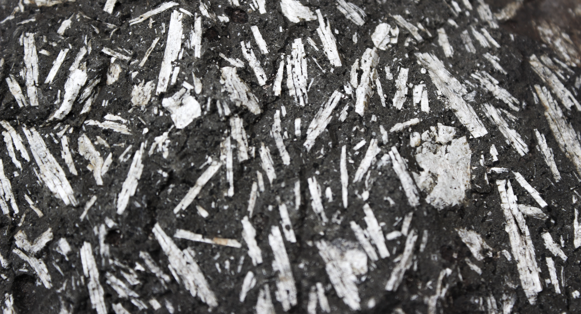
The two darker rocks in this section record the volcanic Cenozoic: (1) The black and white rock nearest the bench, a Trachyandesite, formed when lava abundant in alkali metals and a middling amount of silica cooled so that the white feldspar formed as blades. This specimen may have been collected by former faculty member Dr. Dan Barker. (2) Anchoring the corner of the building is a block of obsidian, or volcanic glass.
UT Geo: For computational geoscientists, the computer is more useful than a hammer or hiking boots. Dr. Thorsten Becker studies the link between movement in the Earth’s deep interior and earthquakes using mathematical models. Similarly, Dr. Luc Lavier quantifies how the Earth’s plates move and change over time.
Look for white “stone” with angular shape
7: Sighting Scope
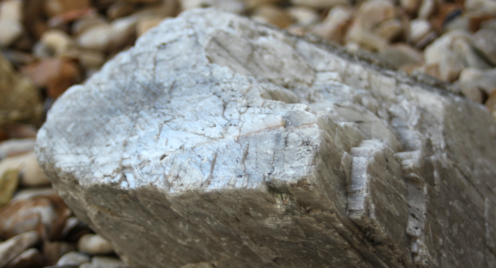
Calcite mineral crystals, like this specimen, break into a rhomb with cleavage points in three directions that are not at right angles. Because calcite crystals like these polarize light, large crystals were quarried in New Mexico to make optics for military use during World War II.
Remember from Stop 4: minerals—including calcite, feldspar, quartz, and mica—are the basic components of rocks and soils. The relative abundance of the different minerals determines is used by geologist to determine rock type. Calcite is one of the most common minerals and is one of the main components of limestones like those that surface the building (Stop 5).
UT Geo: Speaking of scopes, an important source of data for faculty like Dr. Kerry Cook is satellite data. Cook’s research helps better understand and predict the variability of our changing climate by linking broad data from satellites with local observations; for example, a recent paper shows that CO2-induced warming is greatly amplified over the Sahara, and this is increasing rainfall rates across the African Sahel region. She is the author of the textbook Climate Dynamics.
Just north is a larger grouping near the glass wall. Immediately adjacent to the obsidian is a distinctive, curved brown stone as well as a similar but longer second piece of the same formation further north.
8: A Bit of South America in Marble Falls
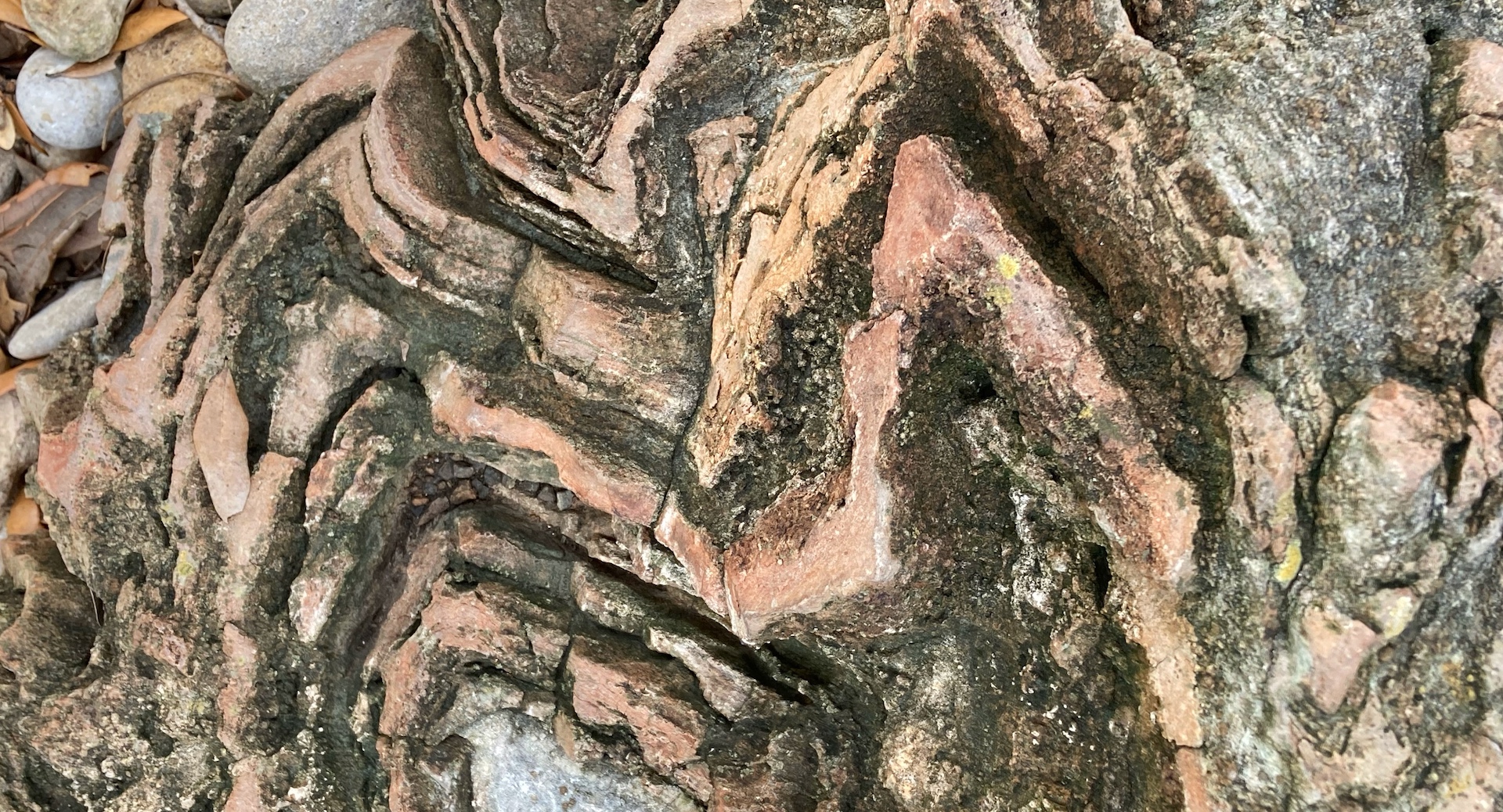
Think of this sedimentary rock—a Smithwick Formation sandstone from Marble Falls—as upside down. It is then possible to see how sand gouging a muddy seafloor during a violent event like a quake or submarine landslide could create the flute-like shapes. The narrow end of each flute is the sand’s point of impact, and the fanning occurred as momentum slowed.
The Smithwick Formation is found northwest of a mountain-marine belt that formed as South America collided with Texas (riding on the North American tectonic plate) to form the supercontinent Pangea. This was about 300 mya, toward the end of the Pennsylvanian period: a time when animals and plants could fully live and reproduce on land, when abundant tropical plants developed into ribbons of coal, and dragonflies and millipedes were gigantic in size because the of more oxygen in the atmosphere. About 180 mya, with further shifting of tectonic plates, the Atlantic Ocean eventually formed, cleaving North America/Europe from South America/Africa. It is only recently—about 3 mya— that South America was linked again with North America.
UT Geo: After a departmental field trip, Dr. Daniel Stockli’s lab tested the zircon minerals in Smithwick material to see if it originated from North or South America. Two undergraduate theses later, the answer was found: the bulk of the sediment that scarred the ancient muddy seafloor came from the hinterland that looks like Yucatan and South America.
Staying with the same grouping, look clockwise around the larger Smithwick specimen, to 7 o’clock and a black rock.
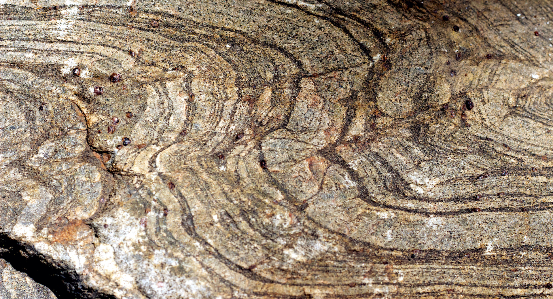
9: Geology 101: Metamorphic Rocks
When high heat or pressure alters existing rock by bending and changing chemistry, the result is a metamorphic rock. Mafic gneiss, as seen in the sample near the pathway, shows the typical banding of gneiss and is made of darker materials—most likely, metamorphosed igneous rock rather than sedimentary rock (with is often lighter). Marble, phyllite, schist and quartzite are other metamorphic rocks.
Pop quiz: Looking in a clockwise circle from the gneiss at 7 o’clock, can you spot the concretion (sedimentary), granite (igneous), and volcanic rock? Hint: they are listed in order!
1) The conglomerate, formed when pebbles and rocks were cemented together by minerals, was collected by Dr. Earl McBride and is a Coaling Ranch Composite from Oklahoma. (2) At 12 o’clock is a sample of Texas pink or Town granite, the unpolished form that is found in the artwork (Stop 1) and from the same source as the rock forming the Texas Capitol Building and the Galvestorn breakwater. This is very old rock and similar to that found at Enchanted Rock State Natural Area, the oldest exposed batholith (a large intrusion of igneous rock, or granite) at 1.08 billion years of age, (3) The “fluffy” white rock, collected by Dr. Rich Kyle near the Rio Grande in Presidio County, tells the story of an dangerous, explosive eruption about 30 mya when simple subduction of oceanic crust under Western North America changed to the rifting (pulling apart) environment seen today. The rock shows inclusions of older rock or broken pieces of the volcano’s vent and parts of the rock show compaction during the lava flow.
UT Geo: In her High Temperature Stable Isotope Lab, geochemist Dr. Jaime Barnes traces volatile elements (in essence, elements with very low melting points) like chlorine, fluorine and other halogens through the subduction cycle. This includes alteration of the seafloor at hydrothermal vents, metamorphism of a subducting slab, and the return of volatile elements to the Earth’s surface through volcanoes.
Walk around the metal fence punched with an Alfred Tennyson line “O Earth, what changes hast thou seen.” This quote is also etched in the first geology building on campus, the Hogg building (WCH) near the Main Tower; if you visit WCH, note the terracotta plaques that include Stegosaurus, Devonian fish, mammoth, and more.
On the east side of the fence and north of the oak, look to the first grouping of rocks.
10: Bending Under Pressure
The long, gray rock with a visible fold contains tiny garnets that formed when heat and pressure transformed the chemical bonds of the original sedimentary shale. Dr. Sharon Mosher collected this roughly 1.4 billion year old metamorphic rock during a field camp visit to the Picuris Mountains, a subrange of the Sangre de Cristo Mountains in northern New Mexico.
Looking closely at this specimen, there are two layers: the whiter bands are quartzite while the darker bands are mica-rich with garnets. Mica has the correct chemical composition for garnets to grow under pressure and heat, usually near plate boundaries.
UT Geo: One tool in the research box of Dr. ELizabeth Catlos are garnets. As this gemstone grows, layers record the pressure and temperature of formation, showing how minerals moved in the Earth’s crust. Catlos extracts information from layers in her laboratory to determine how the Himalaya formed over geological time. Recently, Catlos discovered that garnets also record past erosion events in their formation, expanding the use of garnets as a geochemical tool for understanding Earth history.
Near Stop 10, move a few steps on pavers to a pink and black rectangular cut rock.
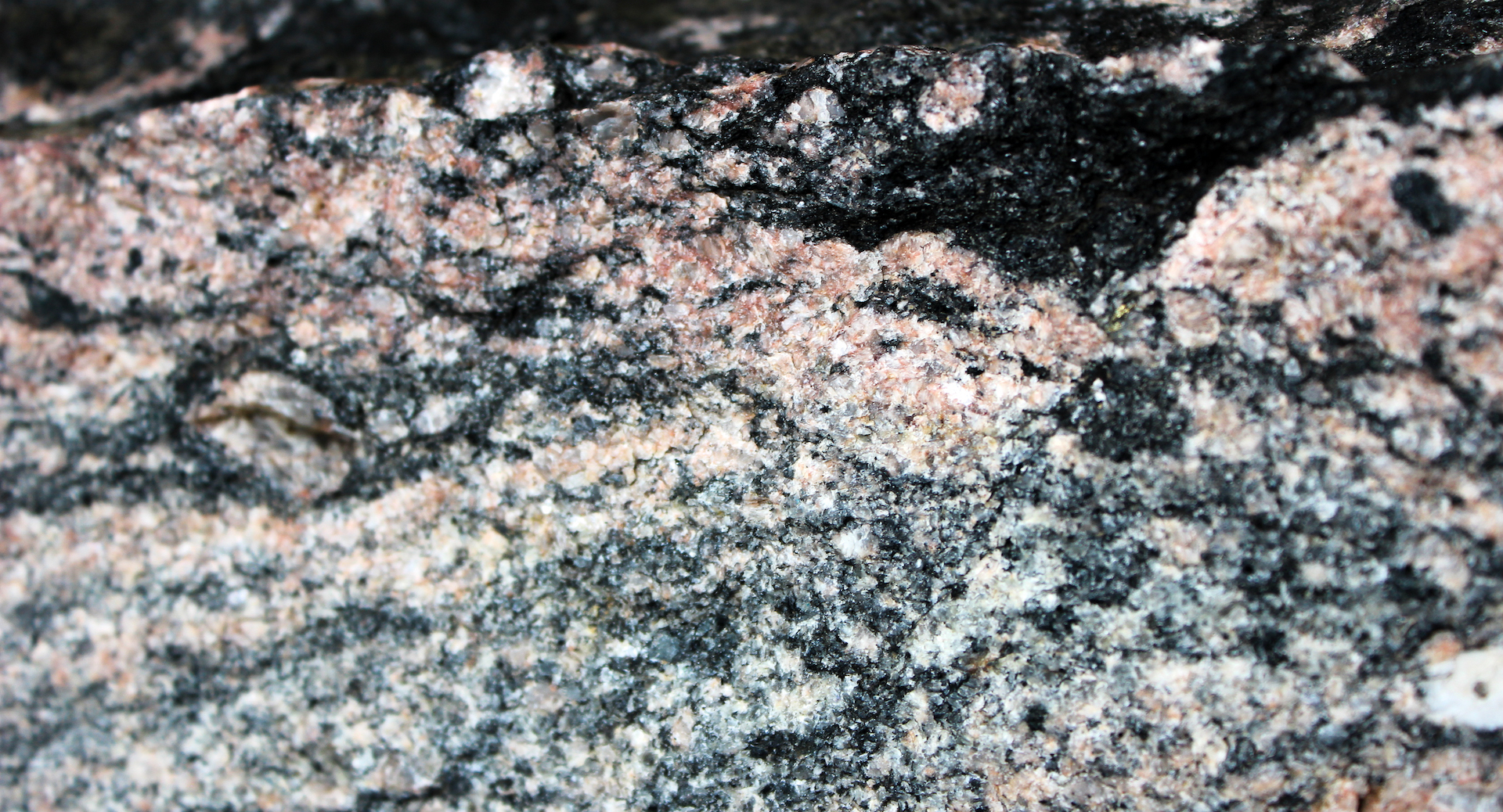
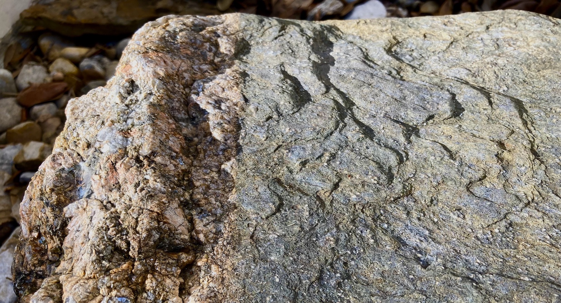
11. Peeking into the Basement
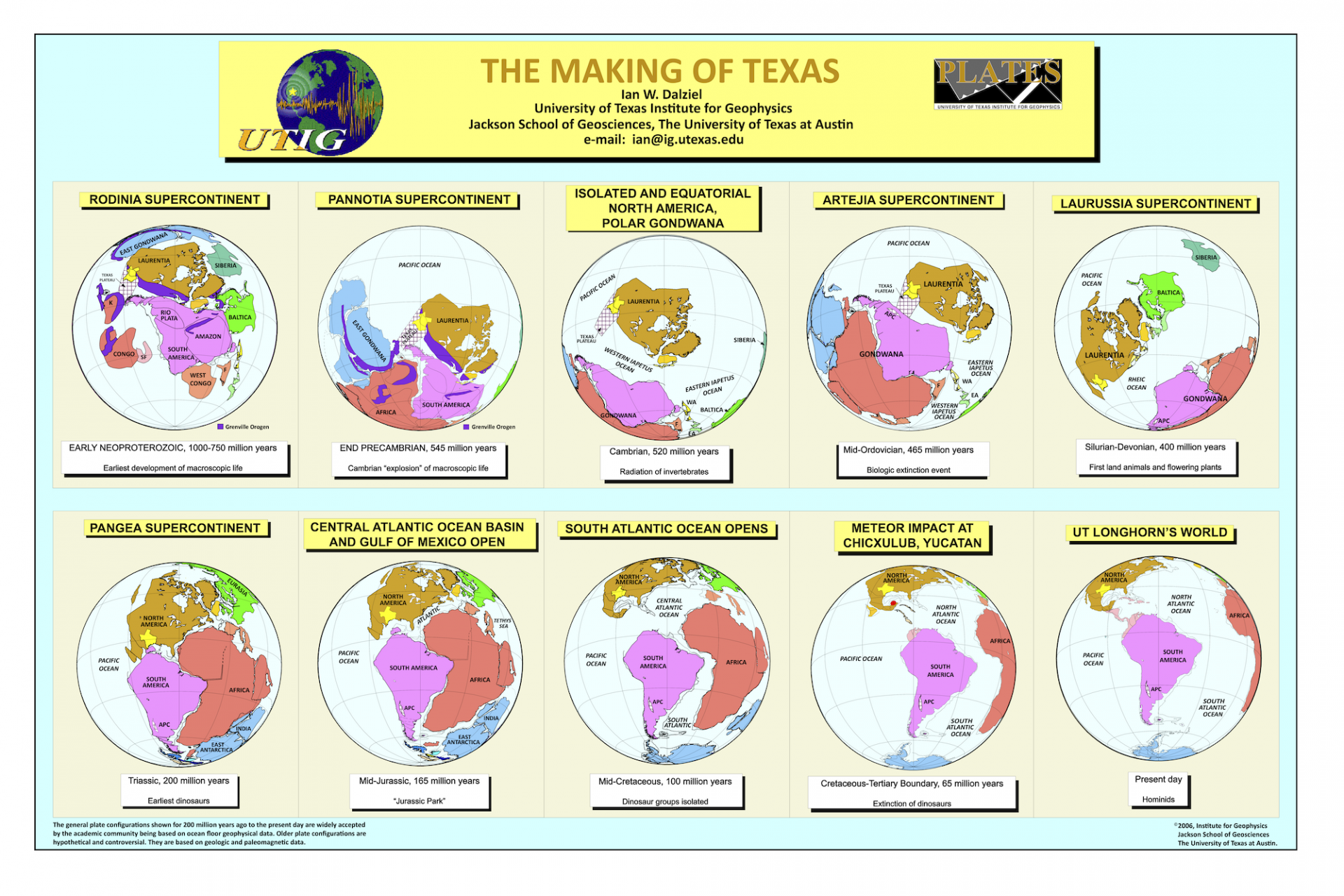
The pink and black gneiss—a metamorphic rock that formed between 1.25-1.28 billion years ago—is the host rock for llanite (see Stop 13). This ancient metamorphic rock was exposed when faulting along the Balcones created a 90 mile-wide island known as the Llano Uplift in the middle of the Hill Country and west of Austin (see the pink section in the image below from Baking Texas). This area is also known as exposed basement rock, or ancient metamorphic and igneous rocks, that form the base of the continent. Basement rock can be 20-30 miles thick and is usually much older than oceanic crust which, given that it is thinner and heavier, is likely to be recycled because of subduction under continents.
UT Geo: Established in 1909, the Bureau of Economic Geology (BEG) is the oldest research unit at The University of Texas at Austin. As the State Geological Survey of Texas, BEG created the surface geological maps of Texas like the excerpt highlighting the Llano Uplift from 1992 (see below).
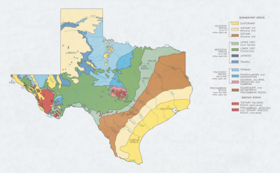
Baking Texas: It’s a special day, so you head to your local HEB to purchase a Texas-shaped layer cake (think stratigraphy with the newest layers—the yellow, cream and light brown in the map—on top). But what you don’t realize is that the plate is flimsy, causing parts of the cake to smush together and others to sluff off (“erode”). This is a very poor visual describing how shifting tectonic plates (movement spurred by heat from radioactive processes within Earth) created today’s geology of Texas. The big events in Texan geology are (from oldest): (1) The ancient rock of the Hill Country and parts of West Texas—the southern limit of the North American Craton—is only visible because the area surrounding it has subsided, leading to erosion that exposed the basement rock that underlies everything younger (Llano Uplift). (2) As shifting tectonic plates met as the supercontinent Pangea, the South American/African plates slowly pushed toward with the North American Plate (linked with European). Folding of marine sedimentary rock and the sliding of the heavier oceanic crust under the continental crust created the Ouachita Mountains—a range that has nearly eroded away after hundreds of millions of years (although there is a tiny bit at Post Park south of Marathon). (3) About 240 mya, Pangea began to break apart, and within another 100 my, a shallow sea—the Western Interior Seaway mentioned above—covered much of Texas. The limestone deposits from this sea are Edward’s Plateau. (4) When the tectonic plates under far west Texas began to pull apart rather than jam together, volcanic activity and faulting occurred between 47 and 17 mya.
Look just south of previous specimen, along curve of pavers, to large rock.
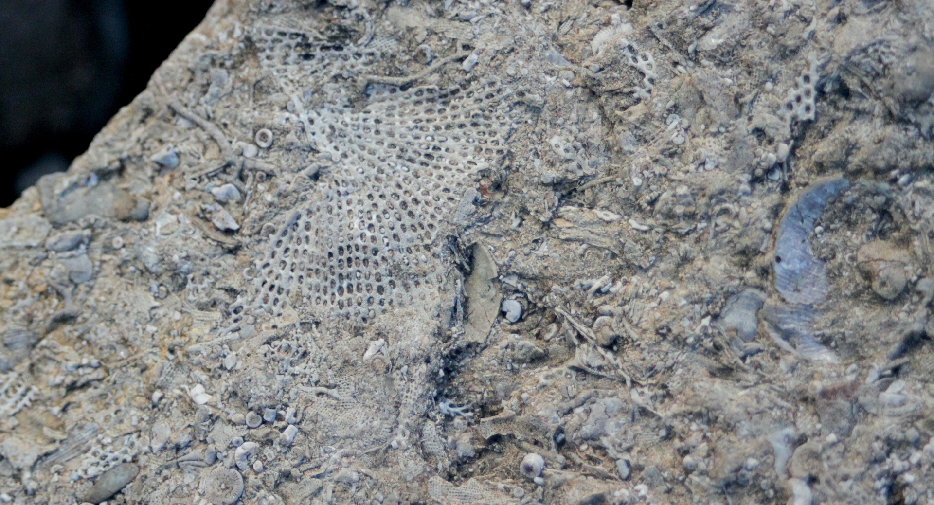
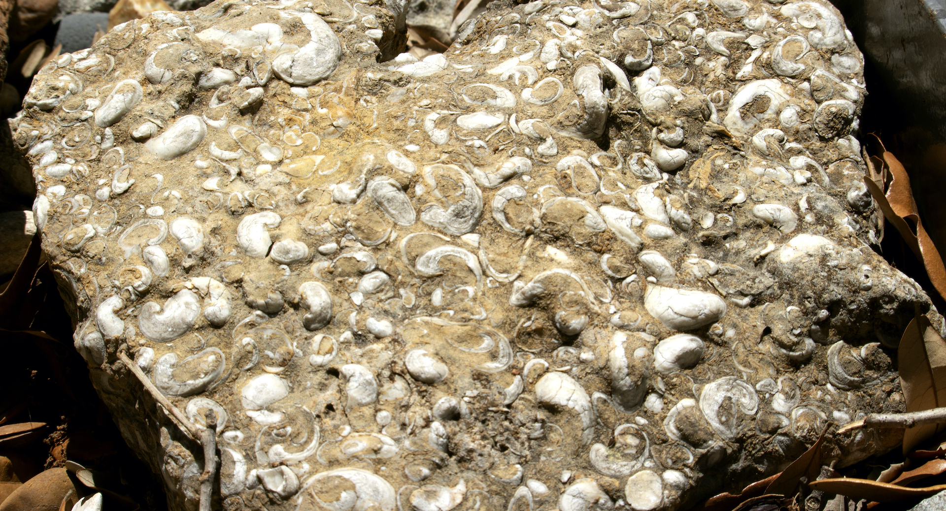
12: Rudist Reef & Tidal Flat in Frozen in Time
Reef-building organisms are now corals, but in the warmer, more saline oceans of the Cretaceous, it was mollusks and other bivalves that built structures for other species to utilize. This limestone is loaded with fossils called rudists, bivalves with teeth that developed into unusual horn or cone shapes. This group of animals was slowly going extinct until the asteroid slammed into the Yucatán, abruptly completing the decline.
The flat and slightly yellow sedimentary rock just west of the limestone was collected by Dr. Mark Cloos while teaching field geology. Found on Spider Mountain near Burnet, the rock is a tidal flat of rolled mud that dried and lithified. Note that lithic means stone.
UT Geo: Field geology is Dr. Miriam Barquero-Molina’s passion. Barquero-Molina, a structural geologist by training, is captivated by all facets of earth science and committed to sharing her expertise with students through experiential learning and field education.
Walk an additional three steps around tree to grouping that begins with long, layered grey stone by plaza tiles
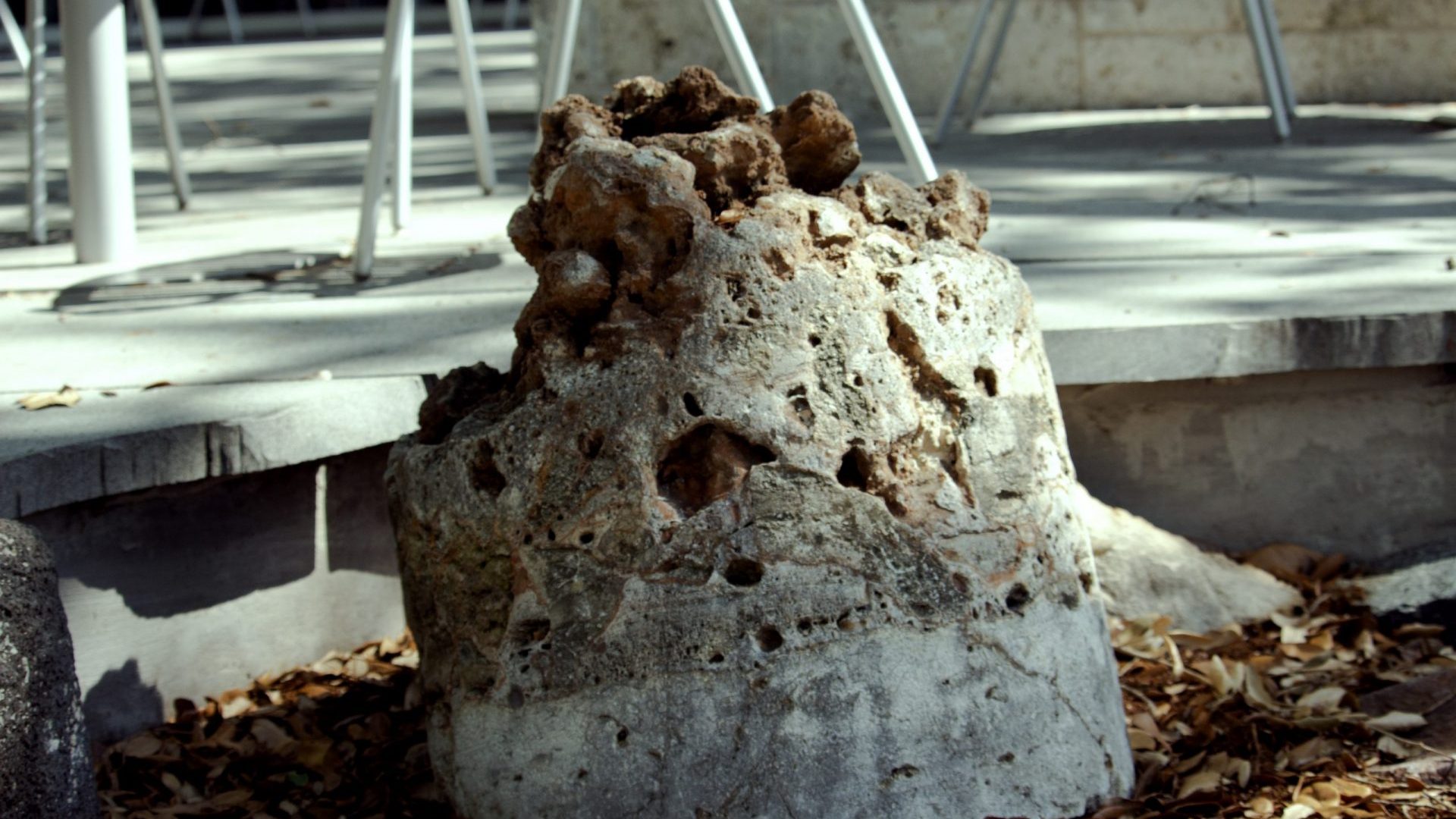
13: Billion-Year-Old Intrusion
When magma squeezed into whatever cracks and spaces it could find within metamorphic basement rock associated with the Llano Uplift, it cooled slowly into an intrusion known as llanite. Llanite, a billion year old (or officially, a 1092 +/-3 mya) igneous rock, was first exposed by the construction of Highway 16 north of Llano. It is some of the hardest rock in the world, a porphyritic rhyolite, and includes a rarity: blue quartz crystals that are usually found in sandstones. Scientists think that the blue formed because of the presence of the mineral ilmenite. Ilmenite contains iron and titanium.
More: Leaning against the rhyolite is a sandstone that shows direction of water flow along an ancient beach. And closer to the tree is another igneous rock of similar age to llanite: a rectangular piece of pink Marble Falls Granite. Like the marbles mentioned in Stops 1 and 9, this stone is quarried throughout the Hill Country.
UT Geo: While many faculty explore Texas as a field site, climate scientist Dr. Dev Niyogi is focusing on how urbanization affects extreme weather. Niyogi’s research is developing planning tools for cities like Austin such as detailed heat maps and examination of critical infrastructure like water supply.
Look toward the pavers for the next specimen.
Stop 14: Metamorphosis
This intensely altered, metamorphic rock—a biotite schist—was collected by the Dean Emeritus of Jackson School of Geosciences, Dr. Sharon Mosher, in the Appalachians. What looks like flaky layers (foliation) are new “flat” minerals (micas) that grew under a directed stress; the layers were not laid down as sedimentary beds. Metamorphism under stress separates the light, felsic minerals from the dark, mafic minerals (silica rich in iron or magnesium). Quartz veins intruded along the flaky layers, and the layers were folded during deformation.
The specimen here resulted from an ancient collision between what is now North Africa and southern New England. One of the oldest mountain ranges in the world, today’s Appalachians were weathered from a height that rivaled the Himalayas. The original mountain chain, or Central Pangean Mountains, formed when two supercontinents, Laurentia and Gondwana, collided between 340 and 290 mya to form the supercontinent Pangea. As Pangea broke up and the Atlantic Ocean opened over millions of years, the original mountain chain split into what we see in the the U.S., the Scottish Highlands, and Little Atlas of Morocco. Today, the Atlantic continues to widen between 0.5 to 4 inches each year.
Right next to this rock is a long, gray sedimentary rock. Can you find it?
UT Geo: By studying materials under high pressure and temperature in his lab, Dr. Jung-Fu Lin has a window into the Earth’s interior. A recent experiment dated the Earth’s solid iron inner core to between 1 and 1.3 billion years old—dates younger than the Earth’s age of 4.5 bya and thought to correlate with a known increase in the strength of the Earth’s magnetic field.
Walk a few additional steps to a rock with numerous bored holes.
Stop 15: Recording the Earth’s Magnetic Field
At the time this volcanic rock cooled, the magnetic minerals within aligned with the Earth’s current magnetic field, creating a time-stamp used for relative dating. Relative dating piggybacks on a known chronology or sequence—in the case described here, magnetic pole reversals—and is different from absolute dating of rocks based on the decay of elements that result in more definite ages.
In the last 83 million years, there have been about 183 magnetic pole reversals. The cause could be change in the Earth’s interior, an extraterrestrial impact, or a large-scale subduction of a tectonic plate. The most recent reversal was about 780,000 ya when the magnetic pole flipped from south to our current north. Although the flips sound instantaneous, they occur over several thousand years.
The tiny cores removed from this rock were analyzed in the department’s Paleomagnetism Research Lab. Paleomagnetism can work with both volcanic and sedimentary specimens and was instrumental in providing proof for the continental drift hypothesis, or plate tectonics, in the 1960s.
Just behind this specimen is a flat sandstone with wood fragments or charcoal.
UT Geo: Newer hypotheses suggest that the growth of the Himalaya stemmed from more than a single collision between the continents of India and Eurasia, an idea confirmed by paleomagnetic results published by Dr. Craig Martin. Martin shows that at least two subduction systems were part of the collision.
Walk northeast toward the rectangular stone the plinth that designates the Jesse Brundett Rock Garden. During the dedication, his wife Ina was delighted to create a place for students and faculty to “meditate or visit or study in an atmosphere of nature.”
Scan to the south and east: this portion of the garden is designed to resemble an “arroyo” or “channel” of rocks flowing from the building to the south and east. Start near the long bench and stay to the west side.
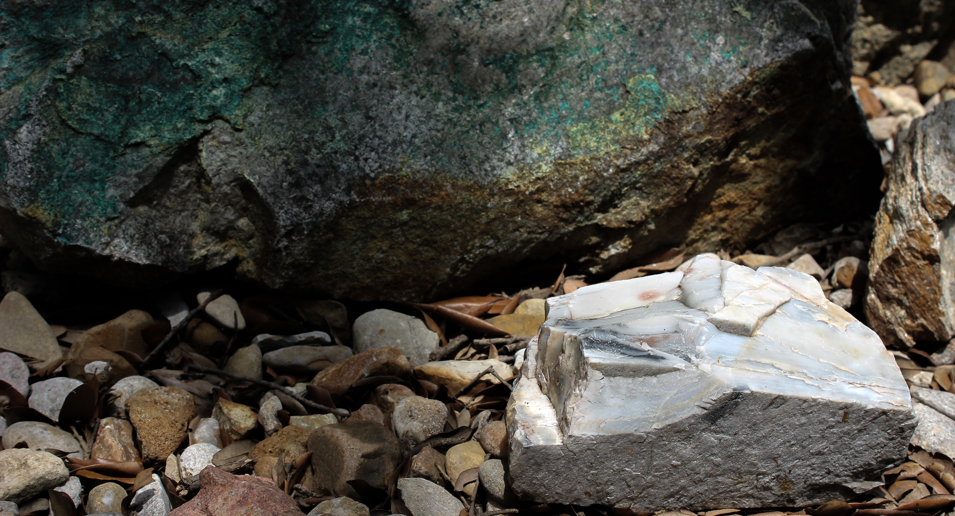
16: Evaporated
Can you see this specimen? A chemical sedimentary rock known as selenite that forms when seawater evaporates? Unfortunately, no. It has evaporated into thin air.
This rock was stolen from the Rock Garden in Fall 2022. These rocks were collected by faculty and students during a century of field expeditions, and these rocks are currently a teaching tool for undergraduates. Please think about the fact that this rock garden is not decorative and belongs to the Jackson School of Geosciences.
UT Geo: A research interest of Dr. Joel Johnson is to better predict how floods change mountain rivers by eroding and depositing sand, gravel and boulders along channels. One approach his research group uses is to put sensors inside of “smartrocks”, which are then put in the rivers and record their movements as they are being transported by floods.
Look next to cavity left by missing selenite to a two-toned rock
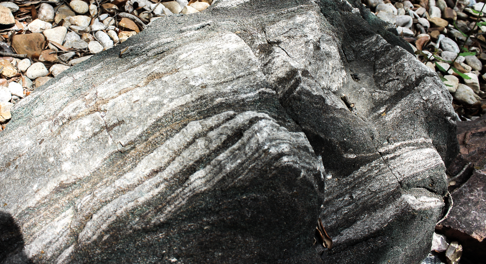
17: Two Toned
Found west of Austin, this specimen is part of the Llano Uplift. The pink portion exemplifies a course-grained, igneous dike. Dikes—made of either sediment or, as seen here, molten magma—are a specific type of intrusion that fill gaps or fractures in older rocks.
The older, gray portion of this rock is a metamorphic gneiss similar to Stop 11, the basement rock found in Texas. In the sunlight, you can see foliation (or stripes in the form of mica) in the rock because pressure aligned the flat minerals. The pink portion of the rock cuts across this older vertical plane and is a pegmatite with wildly varied crystal sizes. Note that the granite crystals that are closer to the gray rock are smaller because the molten material cooled more rapidly (with less time for crystal growth) next to the cooler gray rock.
UT Geo: Much of modern geoscience is not based in field research but is embedded in supercomputers, models, and big data. In studying the flow through porous material (think a sponge or fractured rock), Dr. Marc Hesse combines satellite data, math and physics to map the movement of magma or understand capturing carbon.
Walk a few steps toward the tree and sit on a bench.
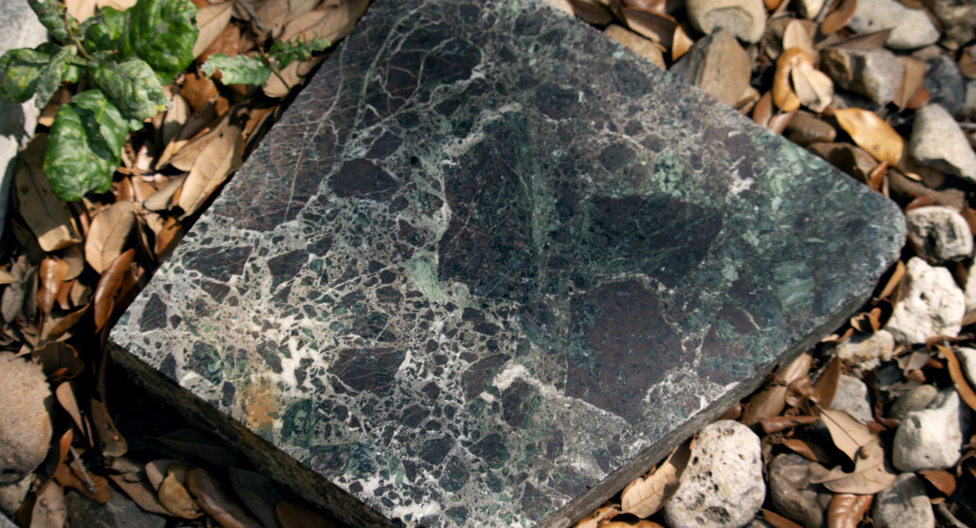
18: Copper, Chert and a Recycled Blue Stone
Found near an abandoned copper mine south of Taos, New Mexico, the large rock with a green sheen is 1.8 billion year old Ortega Quartzite with the colorful copper oxide stain. Copper acquires a green, protective patina over time as this metal reacts with oxygen.
Near this New Mexican stone are two interesting specimens: (1) The smooth, glass-like white rock is chert (also in photo). Chert, with a hardness greater than steel, is called flint by archaeologists and was traded by Native Americans to make tools and blades. Chert is not common but is found as nodules within sedimentary limestones; in fact, most chert forms within rocks as a concretion. A current theory is that sponges have a role in developing cherts because their framework of minute silica needles (spicules) could form the nucleus for a chert nodule. (2) The small blue stone, a sodalite, is a recycled 1.6 billion year old quartzite that was made new about 12 mya.
UT Geo: Dr. Peter Flemings and his research group explore how fluids flow in sedimentary basins. His current passion is the study of methane hydrate—an ice-like substance composed of methane and water. He uses deep sea drilling vessels to take hydrate samples at high pressure to study them on shore. He is exploring the origin of these deposits (were they made by bacteria?), their role in the climate cycle, and their potential as an energy source.
Look southwest of blue rock to see the large banded white and green sandstone
19: Trilobite Skeletons and Poop
The green bands (called glauconite) within this piece of Lion Mountain Sandstone is mineralized trilobite poop, while the gray bands contain fragments of the exoskeletons of the trilobites themselves. Found in the Llano region in central Texas, the sedimentary bands were probably deposited on a sandy tidal flat during the Late Cambrian, the first geologic period of the Paleozoic, and then altered and cemented with calcite. The section of the specimen close to the bench illustrates cross-beds, where the angle of a layer or strata changes because of a change in the environment where sediments were accumulating.
Trilobites were one of the oldest groups of arthropods (invertebrates with an exoskeleton and segmented body), inhabiting the oceans for nearly 270 million years until extinction at the end of the Permian. Today, arthropods make up 80% of all living species, from lobster to insects.
UT Geo: While paleontologist Dr. Tim Rowe spent years rethinking the tree of life, delineating how different clades of animals are related to each other evolutionarily, his most recent research was “stumbled upon, weathering out of a slump block” in northern New Mexico. He discovered a 38,000 year old mammoth with clear evidence of butchering, adding to the growing evidence that suggests an earlier presence of humans in the Americas than the 12,000 year old Siberian “bridge” hypothesis allows.
As the pavers go around the oak tree (with a piece of Smithwick Formation), look to the white rock with thin black bands
20: Time Keeper
Behind a large brown rock with smooth lumps (pop quiz: do you recognize this? Hint: Stop 7, or the Smithwick Formation) is a white rock with fine gray lines. Count the bands: each layer of this chemical sedimentary rock—from the Castile Formation found near Carlsbad, New Mexico—records the annual ebb and flow of a lagoon 280 million years ago. The white layers are gypsum, deposited as water evaporated, while the thin dark bands are the remains of organic material like leaves and laid down during wetter times. Together, the record of evaporation cycles is accurate enough for chronological dating over 250,000 cycles or years. It is one of the longest continual climate records of the Permian period (299 to 251 mya).
There are two additional specimens to note: (1) The red rock between the tree trunk and the Castile Formation is a quartzite (metamorphosed sandstone) with visible cross-beds made by water going back and forth on a tidal flat. (2) The long terracotta brown rock to the left is an elongated septarian concretion. Agates are a form of concretion, and if you look at the cut edge of this specimen, you can see the fractures that are in-filled with calcite.
Walk further around the tree another three paces to the southwest “corner” of the rock garden at the pavers.
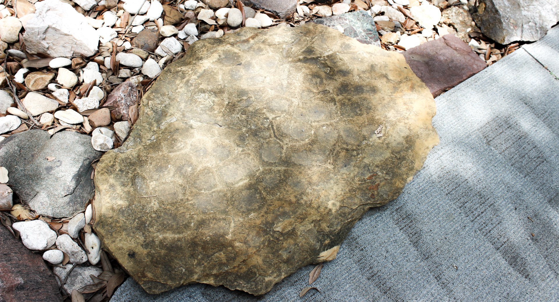
21: Life from a Longer Year
Peer closely at the rock anchoring the corner to see dozens of fossils encased in limestone: fan-like bryozoans, round holes or stems of crinoids, and shells of brachiopods. These animals harken to an era when most life was contained within the oceans. Found in Southern Oklahoma—perhaps the Arbuckle Mountains—the specimen is either Ordovician (485 to 443 mya) or Pennsylvanian (323 to 298 mya when animals like giant dragonflies were adapting to land).
During both eras, the Moon was much closer to the Earth and twice as large in the night sky. Over geologic time the Moon has continually receded from the Earth and the length of the day has increased to its present 24 hours. In the Ordovician, there were over 400 days in a year and the length of a day was only about 21 hours—a fact recorded in the daily and annual bands of corals that lived alongside these fossils peeking from the limestone block.
Why is there a coordinated change in the length of a year and day? The coupling of Earth’s rotation and the distance to the Moon is a consequence of conservation of angular momentum in the Earth-Moon system. The tides of the Moon act upon the Earth, dissipating energy mainly in the ocean tides. To conserve angular momentum while losing energy, the Moon must recede from the Earth and Earth’s rotation rate must slow. Today, the Moon is receding from the Earth about 3.7 cm (1.5 in) each year; this has been measured by laser ranging to the Moon from UT’s McDonald Observatory and other stations. Laser light is returned from reflector arrays placed on the Moon’s surface by the Apollo Astronauts starting in 1969.
UT Geo: As mentioned in Stops 6 and 17, geophysicists use physical measurements to understand the Earth’s systems. One intense area of faculty research is energy exploration, using seismic waves to image the Earth’s interior: Dr. Mrinal Sen works to understand how seismic waves propagate and interact with the rock layers, and Dr. Sergey Fomel works on seismic data analysis and imaging.
Look to gray rock between Stop 21 and the petrified wood (Stop 23).
22: Dumpster Dive
The flat, wrinkled sedimentary rock to the right was found by Dr. Mark Cloos in a city dump in Southern Oklahoma. “It was sitting right there,” he said.
The specimen, from the Atoka Formation, hails from the same time period as the Smithwick Formation (Stop 8) and represents the soft marine sediments deposited in an ancient oceanic trench that were scraped onto land as the North American and South American plates collided. The “wrinkles” are visible tectonic structures made over time as the bed was extended.
The slow shifting of land masses and spreading of oceanic crust occurs because the Earth’s rigid outer layer—heated by a radioactive process within—is broken into a number of slowly moving semirigid plates. Plate tectonics describes how the collision of plates leads to one plate sliding under another (subduction)—creating mountains and other changes to the Earth—and how the divergence of plates at the oceanic ridges leads to new crust formation.
UT Geo: One of the research units of the Jackson School of Geosciences, the Institute for Geophysics, reconstructed the movement of tectonic plate movements over geologic time (see below). Of particular interest is how Texas (in yellow) shifted over a billion years.
Walk completely around curve to south side of oak: petrified log
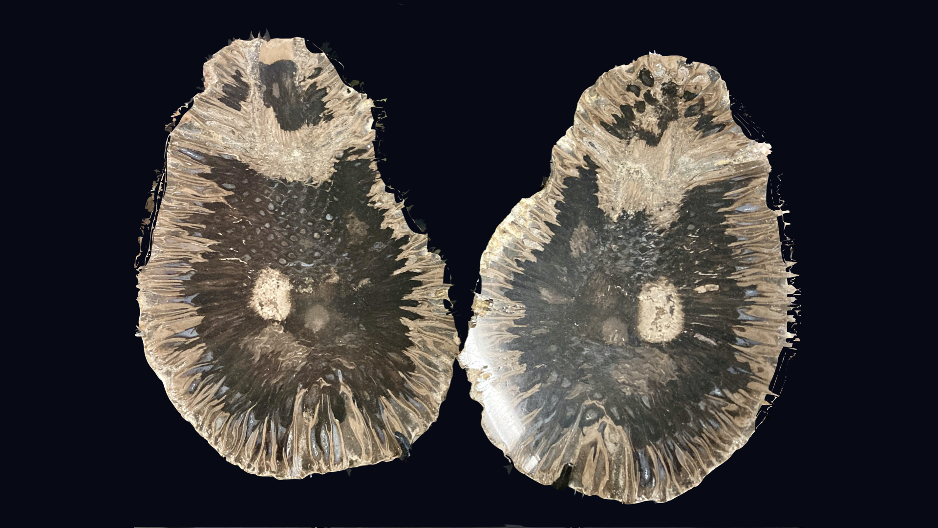
23: State Stone
Petrified wood—specifically palmwood (Palmoxylon sp.)—is the official state stone of Texas, becoming so in 1969 when Governor Preston Earnest Smith signed a House resolution. It is also the state fossil of Louisiana. Most Texas petrified palmwood hails from coastal east Texas, dating from 23 to 34 mya. Known as a very hard (7.5) on the Mohs Scale of Hardness, a scratch-test that determines relative hardness of stones and minerals and that is used to identify different specimens, petrified palmwood was used by Native Americans to make tools and projectile points.
This meter-long petrified log is older than palmwood, a vestige from the Pennsylvanian when plants began to get large on land, or about 300 mya. This specimen was collected in the Marathon Basin. Wood fossilizes like other living material: when silica-rich fluids permeates material over time.
UT Geo: Check out the online catalog of fossil plants curated at the J.J. Pickle Research Campus in north Austin. The Non-vertebrate Paleontology Lab houses more than fossilized plants with a collection of over four million minerals, invertebrate fossils, and even meteorites. Over 22,000 of the items are type specimens, or reference specimens from which species are named. You can see some of the collection on display at the Texas Science and Natural History Museum and the Bullock Museum of Texas History.
Look from petrified wood toward rock near pavers
24: Zig Zag Tale of a Supercontinent
Found near Llano, Texas, this deformed, metamorphic rock got its start as an oceanic sedimentary rock that alternated quartz-rich with carbonate-rich layers. But the Grenville Orogeny, a mountain building event that occurred around 1.1 bya, procured the high temperatures and tectonic stresses to alter and fold the specimen; the softer, gray carbonate layer migrated more readily to the hinges of the folds. Ultimately—once exposed to weather—the carbonate layers also eroded more readily.
The Grenville Orogeny is one of the collisions (in this case, the North American craton running into another continent; see Stop 11) associated with the formation of Rodinia, the supercontinent that preceded Pangea. Rodinia formed between 1.3 and .9 bya and broke apart around 750 mya. Life during this 350 million years was single-celled algae and in the massive ocean. The rusty red, eroding landmasses were barren, especially since, compared to today, the Earth was subjected to more ultraviolet light because of a thinner ozone layer and the atmosphere contained a miniscule amount (5%) of oxygen.
There were supercontinents before Rodinia: Nuna/Columbia at about 1.8 bya and Kenorland at 2.72 bya, the latter which was associated with the creation of continental crust.
UT Geo: Interested in the evolution of planets, Dr. Cheguang Sun’s recent research shows that early in Earth’s history—in the late Archean (2.8 to 2.5 bya) when a watery world changed because of the growth of continental crust—the oxygen “sink” in magmas was reduced which may have allowed atmospheric oxygen to increase.
Walk a few paces east
25: Water Flow in Stone
When water changes direction over loose sediment, the flow is recorded as interference ripples. And when these crests or ridges that formed by flow from multiple directions, are sealed by mud, they can be frozen in time like this sandstone. This specimen came from either the bank of a stream or along a coast.
Walk three steps east to the black rock
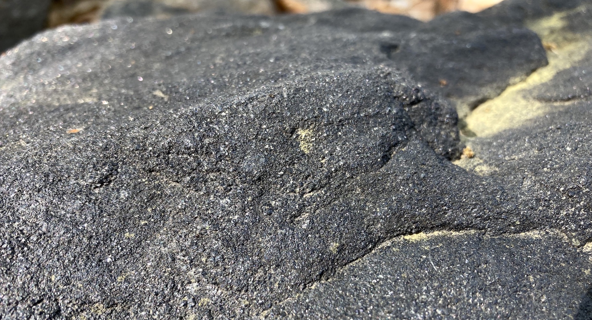
26: Magnetic Attraction
One of the few magnetic minerals, magnetite is a common iron oxide mineral that is found in all rock types. This specimen of gneiss—a metamorphic rock from the Llano Uplift near Valley Spring (northwest of Llano)—is composed mostly of magnetite ore; if you have a magnet, it will stick!
More: Look at the rectangular cut pink granite on the other side of the“river.” Close examination shows a small triangular xenolith or “foreign rock” of schist, a dark metamorphic rock that was picked up by the intruding magma as it crystallized to form the pink granite. The schist would be older than the host rock.
UT Geo: By studying how sedimentary environments evolve both today and in the past, Dr. Matthew Malkowski has insight into the forces (such as climate, human activity, sea level change, or tectonics) that create landscapes. One recent paper modeled underwater erosion along a continental margin—the Bering Sea—and found that the rebound of the continental shelf in response to sediment removal was too great to only have occurred in the Pleistocene.
Walk east about five more steps to where the rock “river” begins to bend

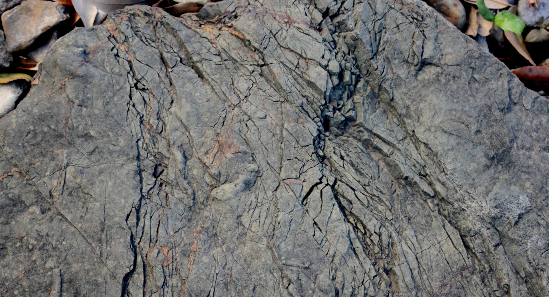
27: Folded Strata
The Rocky Mountains extend for some 3,000 miles from central New Mexico into Canada. The Northern Rockies include the Pioneer Mountains of southwestern Montana where this metamorphic rock was collected. As mentioned in Stop 6, the Rockies began forming about 60 mya. This is an unusual mountain chain—formed far from tectonic plate boundaries—that most likely rose because of a number of tectonic plates slid under North America at a shallow angle.
When you look at the folded metamorphic rock, a quartzite from the Pioneer Mountains in southwest Montana (Silver Hills Formation), you are seeing the result of a regional mountain building event and a probable collision of land masses. A previous Cambrian mud or sandstone was moved 6 to 8 km below the surface about 80 mya where the heat and pressure reshaped rock into the form seen today.
UT Geo: During the last Ice Age, glaciers scraped northern North America. Today, Dr. Ginny Catania researches glaciation near the poles, focusing on the complex reasons for melting in places like Greenland. Climate change may be forcing glacial retreat, but many factors impact glaciers and make accurate predictions of melt challenging.
Look slightly north to the specimen adjacent to the previous rock.
28. Almost Life-Like
No, it is not a honeycomb. This sedimentary rock formed from a previous incarnation, one made of concretions that shrank, that allowed calcite in groundwater to move in and form what looks like cell walls.
Walk east to the edge of the courtyard and look down (and east) into the “pond” under yet another Southern live oaks. Look down: the first specimen is right where the narrow “channel” of rocks flows into the “pond”.
29: When Continents Pull Apart
Rift valleys—much like the oceanic spreading zones—develop when two tectonic plates pull apart. The Rio Grande Rift developed over 30 million years between the Colorado Plateau to the west and the North American craton to the east. The fault line associated with pulling tectonic plates apart allows magma to move in, creating lava flows. This black basalt—sitting next to another piece of the black and white Castile Formation similar to Stop 20—is from the youngest layer of the Carrizozo lava field from New Mexico north of White Sands National Park. Look for this volcanic formation as you fly over the center of New Mexico; it is visible from space.
Most volcanic rock on Earth (90%) and on other planets in the Solar System is basalt. Basalts are extrusive igneous rocks that form when slow moving magma from the Earth’s Upper Mantle, which is rich in magnesium and iron, cools near or at the surface of a planet. This large black rock is vesicular because it hardened before the gasses in the magma could escape, leaving holes or vesicles.
UT Geo: There is a “clean lab” within the building where geochemist Dr. John Lassiter has a window into the origin and evolution of the Earth. Lassiter measures the trace element or isotopic compositions of rocks to better understand how the composition of Earth’s interior records processes such a plate subduction or melt extraction; for example, certain signatures found in xenoliths from the Colorado Plateau suggest a change in the mantle composition as the Farallon plate—with its serpentine—was subducted beneath North America.
Look towards a black rock halfway to the oak tree trunk that is centered in the “pond”
30: Pumice
Can you guess what this rock is? This is also a vesicular basalt, as in Stop 29, although the gasses released after exposure to the surface left larger pitting.
Basalt is most of the Earth’s crust, the oceanic crust. Some basalt erupts near subduction zones along continental margins or as oceanic islands, but most is generated in the deep sea at the mid-oceanic ridges as tectonic plates move apart, creating new crust. The ridge running along the middle of the Atlantic Ocean spreads between 0.8 to 2 inches each year while the ridge in the Pacific spreads more rapidly, or up to 6 inches a year.
The oceans have always acted as an essential flywheel of the global climate system, now—with climate change—absorbing around 90% of the energy trapped by anthropogenic greenhouse gasses and receiving close to 100% of the meltwater from land-based glaciers and ice sheets. This is leading to oceanic warming and acidification as well as sea level rise. Understanding the ocean’s interactions with the global climate system is essential to improving our understanding and its predictive capabilities.
UT Geo: The Arctic is a hotspot of climate change, with observed increase in Arctic air temperatures 3 to 4 times larger than the global mean and increased loss of sea ice during summer months. With numerical models or simulations that are calibrated with observational data, Dr. Patrick Heimbach and the CRIOS group work to understand variability in heat, salinity, and currents in the ocean over time, and their response to climate change. Recent work with colleagues led to an award-winning visualization of Arctic Ocean currents and sea ice.
Look beyond the tree trunk to the white turtle sculpture among the palmettos

31: Turtle at Rest among Palmettos
Alumni and their generous contributions are essential for faculty, researchers, and students to continue to thrive at the Jackson School. Living among the palmettos at the back of this section of the courtyard is a white turtle. It was sculpted from marble by Anny Coury, a petroleum geologist who graduated in 1949.
The Texas Palmettos (Sabal mexicana) that thrive on campus today would not have survived Austin’s winters a century or two ago. Our changing climate and Austin’s urban heat island have allowed garden escapees to colonize nearby Waller Creek. If you are looking for additional learning opportunities, there is a mile-long walking tour of Waller Creek that highlights the corridor’s importance to research, history and biodiversity on campus.
UT Geo: Because of his research on streams and the impact of urbanization on water quality, Dr. Jay Banner is one of several UT Austin faculty featured in the Waller Creek tour mentioned above. Banner—an expert in past climates and hydrology—contributed to the Fourth National Climate Assessment (2018); look for the next assessment sometime in 2023. Banner also founded the Environmental Science Institute’s’ signature Hot Science – Cool Talks, and while seeing talks in person is fun, there is also video archive with access to over 125 fascinating scientific lectures.
Staying on the pavers, carefully cross the narrow “channel” so that you are next to the big core
32: Core Concept
When I-35 was built, it shadowed older North-South roads which in turn followed the Chisholm Trail and even older paths. The trail—which lasted for about two decades after the Civil War until barbed fences sectioned the land—allowed Texas ranchers to drive cattle to the railroads in Kansas.
Much of human land use is rooted in geology: cities develop by rivers and roads take the easiest way that topography allows. What became I-35 flows along the Balcones Fault Zone—remnants of a continental collision 300 mya that formed the now-eroded Ouachita Mountains. This is why it seems that the interstate separates the thin soils and ranch lands of Edwards Plateau from the rich blackland prairie to the east. The most recent earthquakes along this fault zone were more than 15 mya, most likely because of the vast amounts of sediment that forced the coastal plain of the Gulf to subside.
This core was pulled from the Earth near Georgetown as crews were constructing I-35. Instead of making a hole for a road footing, the crew punched through limestone and into a cave. Now known as Inner Space Caverns, this is one of many caves along the fault zone. Other features are karst aquifers and springs (like Barton or San Marcos) created by water seeping into limestone caverns over millions of years.
UT Geo: Although much of Dr. Nicola Tisato’s research is in the lab—torturing rocks, as he puts it, to better-understand earthquakes—he also studies the structures formed in caves by water and minerals. A recent trip to Inner Space Caverns with Dr. Charles Kerans—who also has wide research interests that center on stratigraphy—looked at how water made its way underground.
Look toward the tree trunk to an unusual light gray stone
33. Pressure Makes Flexible
Found on Blount Mountain, south of Llano, this calcium-bearing silicate (a metamorphic rock known as calc-silicate) was infiltrated by fluids during metamorphism and folded. If you look closely at the lines parallel to the folded axis, you can see material “flowing” into the hinge: it is thicker in hinge and thinner on limbs.
Walk along the pavers toward light post
34: Hexagonal Column of Seafloor
The dark rock is a basalt from the Knippa quarry near Uvalde, Texas. It took a determined, strong student to drag this specimen to the Rock Garden while on one of a former faculty member’s, Dr. Richard Kyle’s, field trips.
This basalt formed during a time of tectonic upheaval in Texas when seafloor spreading and continental rifting at about 87 mya led to volcanic activity known as the Balcones igneous province. This basalt has an unusual hexagonal shape and columnar jointing.
The pink granite next to the basalt includes a darker igneous dike. The dike is an apilite with a mineral composition that is the same as the granite (that is, it is similar to the rock in which it intrudes) but is much finer grained. The specimen is from a quarry near Austin.
UT Geo: Previous snippets have introduced several faculty who use simulations to study our changing climate. Research by Dr. Geeta Persad underscores the impact of particles in the atmosphere (known as aerosols) on temperature, rainfall, cloud formation, and extreme events. Aerosol pollution changes rapidly in response to human activity and is important for both climate change and human health.
Keeping on the pavers north of the “ravine”, walk back along the narrow “channel” toward the second oak
35: Is This Marble?
At first glance, this shiny, polished rock might be marble. But don’t let its finely ground surface fool you! This is sedimentary, not metamorphic, rock—a breccia that was collected along the northwest coast of Italy. In fact, this formation was the subject of a long-standing debate about deep vs. shallow water deposition between former faculty members Bob Folk and Earle McBride.
Essentially angular, broken pieces cemented together, the breccia contains large reddish inclusions of hematite, or iron ore that rusts when exposed to the atmosphere. The redness in this specimen means that it was most likely formed above the water table. But these hematite inclusions had an earlier life as bits of seafloor. The largest deposits of hematite date to about 2.4 bya when cyanobacteria, evolving the ability to harness energy from the Sun through photosynthesis, began to add oxygen to the Earth’s atmosphere. As oxygen combined with the then iron-rich oceans, massive banded iron deposits were created on the seafloor.
Glance toward the curve of the “ravine”
36. Eroded Gold
Fools gold is often an accessory. Not the kind of accessory that you may wear—such as a bracelet of gold or silver—but as a mineral that is often in amounts too small to influence a rock’s composition or name. It is easy to see this concept on this Llano sandstone with the tiny, rusty inclusions of fools gold (also known as pyrite). With a chemical composition of FeS2, pyrite changes when exposed to the atmosphere: the sulfur oxidizes and the iron rusts.
UT Geo: Dr. Kyle Spikes uses human-made seismic waves, complex statistics, and machine learning to improve the discovery and delineation of oil and gas reservoirs. One recent paper improves subsurface imaging by better understanding how pores in rocks scatter seismic waves.
Walk a few steps north
37. Rift Valley
This quartzite was collected in the Picuris Mountains, a subrange of the Sange de Cristos in northern New Mexico. It is a fault breccia, created when the mountain’s underlying Precambrian quartzite was broken into angular chunks because of more recent, complex faulting associated with formation of the Rio Grande Rift (for more on the Rio Grande Rift Valley, see Stop 29). A finer rock cement holds the older rocks together.
Continue to walk along east side of the “ravine” until level with the plinth, a large cut stone that anchors the rock garden.
38: A Rarity from Lake Travis
Celestine or celestite crystals precipitate out of water, growing from the walls inward. The crystals are often found in cavities within Glen Rose deposits of the the Early Cretaceous, the ammonite-and-bivalve-filled limestones created by the Western Interior Seaway (see Stop 5). This unusually large specimen was found by a man in the 1980s while constructing his home near Lake Travis.
Found throughout Texas, the Glen Rose formation was named by Robert T. Hill in 1891. Hill—one of the pioneering geologists of Texas—had recently completed his stint as the first chair of the new geology department at UT Austin (on the faculty from 1888 to 1890).
UT Geo: It is a short walk (about three blocks) to the north side of the Texas Science and Natural History Museum’s building. There, you can see the Glen Rose footprints made by two dinosaurs about 112 mya. A sauropod and theropod left traces in coastal mud that is now exposed rock along the Paluxy River in Glen Rose, Texas. As you travel through Texas, you can see dinosaur footprints at a number of locations.
Walk across “bridge” made of pavers to a small display of specimens by the building’s entrance, near the plinth that designates the as the Jesse Brundrett Rock Garden.
39: The Fossil Corner
There are two fossils in the southwest corner of the “ravine” near the JGB building’s wall of glass that opens into the cafe and student center. The specimen pictured above is a sedimentary rock, a Cenommanian sandstone, chock full with Texigryphea sp. oysters.
Why are there so many oysters? This is a thanatocoenosis, a death assemblage of an entire ecosystem created when a significant storm hit shallow seas. Found in south Texas with a type section hailing from Del Rio, the fossils date to the Cretaceous at about 98 mya when much of Texas was covered by shallow, warm waters. The Cretaceous ended at 66 mya with the extinction of dinosaurs and ammonites (see Stop 41), the fifth mass extinction that opened niches for mammals and birds to inhabit.
Can you find the piece of petrified wood nearby, the second fossil?
UT Geo: While Dr. Rowan Martindale researches ancient extinctions, working to understand the response of reefs to catastrophic events, she has also created a paleontological board game. Check out Taphonomy: Dead And Fossilized, a game that teaches players about fossilization through competitive play. And look our for Dr. Martindale’s new game that will be available soon called Reef Survivor.
Look at a large pale green specimen midway toward glass wall
40: Oceanic Crust Thrust onto Texas
On the far right, next to the ammonite, is a piece of Coal Creek Serpentinite—a Precambrian (1.3 bya) chunk of oceanic mantle that formed beneath an island arc. Like the Aleutian Islands in the Bering Sea, island arcs are curved chains of volcanic islands that form when one oceanic plate subducts under another. In this case, the rock was thrust onto the continent (well, onto Laurentia, as it was known at the time).
Metamorphic serpentines, which feel soapy when touched, form at lower-than-normal pressure and temperature in the upper-most mantle, the mostly-solid section of the Earth that is just below the crust or outer layer.
UT Geo: In addition to laboratory experiments on rocks like these, Dr. Demian Saffer heads to the field to monitor the “creaks and groans” emanating from active faults at deep ocean trenches in order to better understand the dangerous earthquakes and tsunamis that happen there. Saffer also directs the Institute for Geophysics.
Look at the specimens close to the glass wall.
41. Ancient Predator
Ammonites, related to today’s octopi, were predators of the oceans between 415 mya and 66 mya. But these cephalopods went extinct along with dinosaurs and an estimated 50% of animals and plants after a 10-mile-wide meteor hit Mexico’s Yucatán Peninsula at the end of the Cretaceous, or at the K-T boundary. This was the Earth’s fifth mass extinction, following events 210 mya, 250 mya (the largest mass extinction event), 365 mya and 440 mya. Initiated in different manners, the common thread through all extinctions was a rapid change in climate and environment.
This specimen, preserved in limestone, is most likely from Austin; the creeks and streams throughout town carve fossils from stone every year. In fact, a Protexanites planatus was found in limestone along Waller Creek just south of this courtyard.
UT Geo: Dr. Sean Gulick and colleagues explored the asteroid impact that caused the fifth mass extinction. By drilling into the Chicxulub impact crater in the Yucatán, the team found evidence of granite and carbonate material melted by the impact, crystals altered by extreme pressures, processes that caused the crust to flow like a liquid, and kill mechanisms such as earthquakes, tsunami, and climate changing gas release.
Before entering the building, look east to two areas set aside to commemorate two beloved faculty members: Drs. Stephen Clabaugh and Leon Long. Enter the door into the Holland Family Student Center. If the cafe is open, this is a great spot for a break. Look down at the floor to see a continuation of the “ravine” inside.
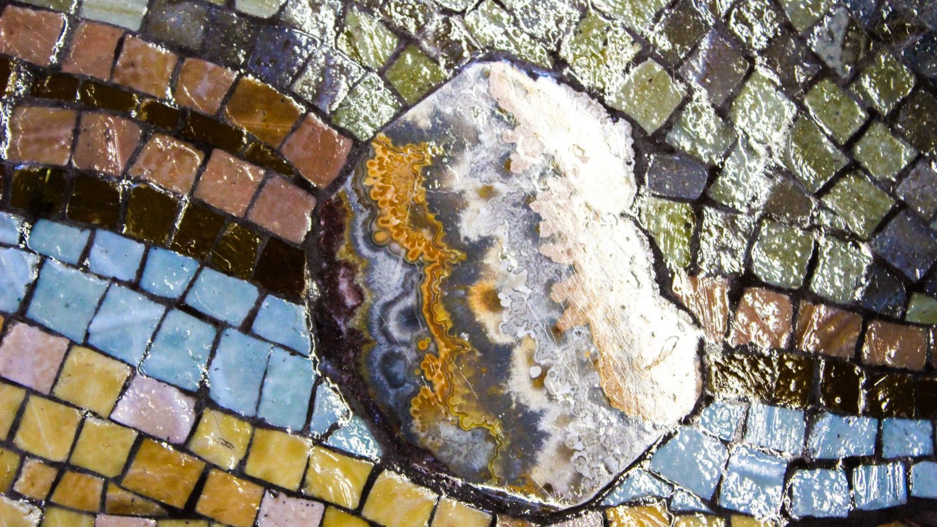
42: River of Time
The River of Time mosaic reminds all that the Texas landscape is still changing – in part by water. In Texas, 14 major rivers, including the Rio Grande, Red, and Colorado rivers, carve new vistas and move sediment from the mountains to the ocean.
Artist Julie Richey used tweezers to assemble this mosaic, the tile enhanced by the departmental history running through it.Several of the polished stone slabs were associated with doctoral dissertations and the others were part of the departmental collections: petrified Texas palm wood, obsidian, Brazilian banded agate, Bandera Mesa jasper, Utah’s green variscite, poppy or leopard jasper, feldspar (or clear moonstone), Lapis Nevada, limestone with rice-shaped fossils, quartz, Australian tiger iron, Indian bloodstone, rhodonite, and blue sodalite.
Richey’s mosaics and sculptures have been shown in the U.S. and in Italy. In 2009, her work was awarded the Orsoni Prize, the International Award for Mosaic Fine Art.
Near the cafe is a large yellow-orange specimen on display.
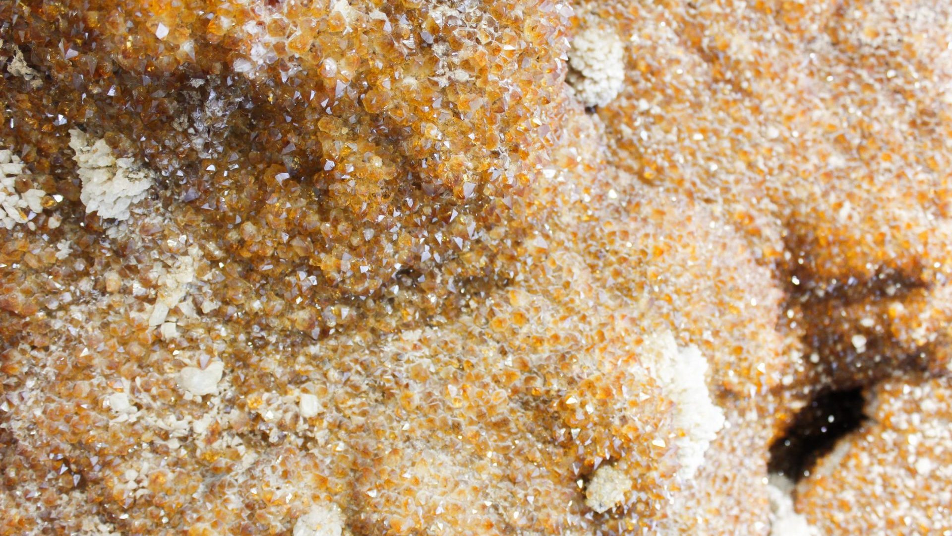
43: Geode
Citrines form naturally when amethysts or topaz (smoky quartz) heat and change color. Donated by an alumni, this semi-precious specimen weighs 1500 pounds and required special beams and braces to hold it in place. In fact, much of the JGB building was built to hold a huge amount of weight since many of the collections are, well, heavy rocks!
UT Geo: Curious about the gemstones in the geology collection? Check out the online database of the Glenn and Martha Vargas collection.
Walk slightly north west to the main desk and look behind.
44: Backdrop
Setting the stage for visitors to the front desk—nothing screams geology like massive rocks—these slabs of black and white marble hint at a sedimentary past with banded layers of white and black carbonate. But heat and pressure metamorphosed the rock. Later, the marble layers were stretched and the more rigid black layers fractured, forming elongated boudins (the French word for sausage) and then was compressed and folded. The void between the black boudins was filled with white calcite. Boudinage, or the breaking of a layer or vein in response to stress, occurs in sedimentary and igneous rocks as well.
In this specimen, some of the boudins were pulled apart further; look for the garnets that grew during this process. These slabs were discovered by Dr. Mosher in a warehouse in Austin.
Turn around and walk through the glass doors and down the hallway. This hall is lined with display cases.
45: Sauropod Forage and Fossilized Squids
These fossilized pine cones, Araucaria mirabilis, fell from trees that towered over 300 feet tall during the Jurassic. These conifers were dined on by long-necked, titanic sauropod dinosaurs—known for swallowing their food whole—that were able to move on land because air sacs within their bones reduced their overall weight.
Although this genus of pine was once widespread, there is only one living relative: the bunya pine found in Australia.
In another display case, squids from the Cretaceous present an extraordinary example of the preservation of soft tissue.
Continue down the hall a few more steps.
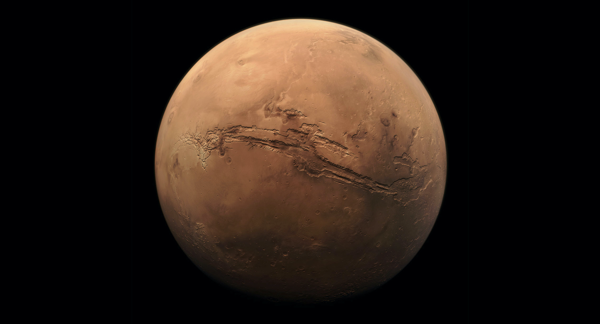
46: Research Roundup on the Red Planet
On the right side of the hall, two displays pinpoint how Jackson School scientists have impacted research on the Moon and other planets. For example, faculty from UT Austin, in conjunction with scientists all over the world, suggested that NASA’s Perseverance land on Mars’ Jezero Crater where there was evidence of water flow about 3.5 bya. Launched in 2020, this rover is now collecting images that confirm boulders were moved by water and is looking for signs of ancient microbial life. And we can all now hear the sounds of that distant planet.
UT Geo: Faculty member Dr. Tim Goudge reconstructs the evolution of sedimentary rock on Mars, including the role that wind and water played, with remote sensing data. Here on Earth, his team uses drones and laser pulses (LiDAR) to map topography in precise detail.
Continue down the hall, passing four squares of marble on your left, and turn right. You will walk past plaques denoting contributions to the Geology Foundation and toward the Boyd Auditorium. Look to your right (east).
47: Winged Texan
One of the largest pterosaurs, Quetzalcoatlus northropi, was discovered by Douglas Lawson in 1971 in Big Bend National Park. Lawson once stated that it was “like a flying giraffe … with wings much more like bats” … although pterosaurs use only one digit to support the membrane for a wing. Q. northropi dates to about 68 mya and had a wingspan about three stories, or between 33 and 36 feet. Pterosaurs went extinct along with large animals at the end of the Cretaceous, although birds—essentially flying dinosaurs—did survive the K-T boundary.
The fossil is part of UT’s Vertebrate Paleontology Lab. Started in 1949 under the direction of paleontologist Dr. Jack Wilson, the VPL is the seventh largest fossil collection in North America and is utilized by UT and visiting scientists for research. Dr. Wilson’s work was recently retraced by his granddaughter in a Texas Monthly feature.
Walk back the way you came and continue south towards the exit on the East Mall. Across from the elevator bank is a large commissioned piece of video art.

48: An Interval of Time
This display is one of about 50 public artworks curated by the UT Austin’s Landmarks program. Created by Miami-based Monika Bravo—an artist who explores “reality as perceived through our relationship to space and time”— combines geological data with imagery from Iceland, New Mexico, Colorado and Colombia. Bravo’s inspiration is weaving together the spiritual and science as non-linear impression of time.
Enjoy visiting other artworks throughout campus. Each piece listed in the collection has its own audio guide.
From here, you have two options. (1) continue to walk to the exit on the East Mall, or (2) take the elevator to the 4th Floor.
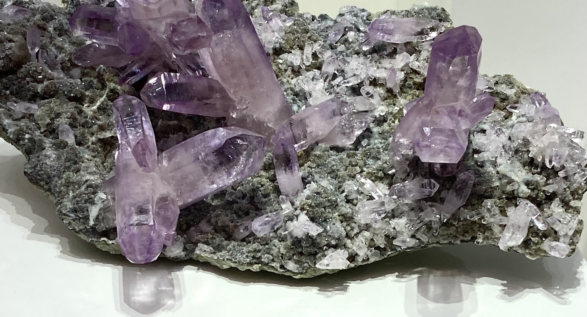
49: Library and Hamman Mineral Gallery
Take a minute to pursue a beautiful display of gems and minerals, the Henry R. and Ann N. Hamman Gem and Mineral Gallery, on the 4th floor. The display is a new highlight of the Walter Geology Library which houses a remarkable collection of specimens, survey reports, field notes and letters, digitized research and journals, and maps.
UT Geo: The gems and minerals in the gallery are more than nature’s beautiful art. The specimens in the gallery are also repositories of geologic information. As curator, Dr. Kenny Befus helps scientists across the Jackson School leverage the gem and mineral collections for research. Current projects are investigating diamonds from across the USA, blue Texas topaz, and Paraiba tourmaline.
Walk down hall to second elevator bank. When finished, take the elevator to the second (ground) floor.
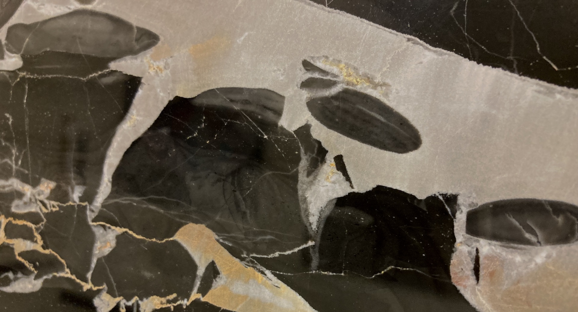
50: State of the Union
It’s the 50th stop, and there are 50 states!
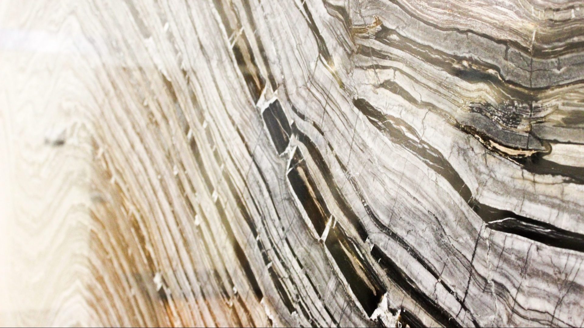
When delivering the State of the Union address to a joint session of congress, presidents are flanked by more than the Vice President and the Speaker of the House. Two enormous columns of black and gold frame the scene, columns of Portoro marble quarried near Italy’s Gulf of La Spezia that opens west into the Ligurian Sea. Several past students did field research on this stone, and samples—like this one— have been brought back to UT for laboratory analyses.
Portoro marble developed when aragonite mud—deposited in a lagoon 205 mya—was metamorphosed into calcite microspar. The white masses are dolomite, the light gray nodules are sites of early bacterial-induced conversion of sediment into rock (or diagenesis), and the yellowish sections are the result of oxidation and solutions. One fun fact: Portoro covered the 1989 departmental newsletter, and the current newsletter is an excellent way to check in with research, scientists, and students at the Jackson School of Geosciences.
Looking to the right note another large slab—this time of limestone from the Rosso Formation in Lombardy, Italy.
This walking tour was conceived of and written by Kristin Elise Phillips with photographic assistance from Kathryn Gatliff and Alex Walters. Angelica Reyes coordinated recordings and provided content. Thank you to Mark Cloos, Mark Helper, Sharon Mosher, Tim Shanahan, Richard Kyle, Earle McBride, Charlie Kerans, Jim Sprinkle, Danny Stockli, Jim Gardner, Nicola Tisato, Clarke Wilson, and others for assistance with information.